


|
||

|

|
|

|
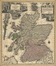
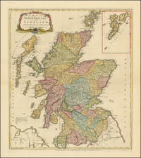
Rare separately published sea chart, extending from the northernmost coast of Ireland to the top of Scotland, including all of the Hebrides and Western Islands.
Dedicated to the British Society for the Encouragement of the Fishery (British Fisheries Society), this remarkable chart includes profiles views, extensive soundings and arrows noting the direction of the currents.
The British Fisheries Society, operational from 1786 to 1893, played a notable role in the history of the British fishing industry, especially in the Scottish Highlands. Initially, the Society focused on developing settlements in the west, such as Ullapool and Lochbay, with the aim of boosting the herring fishing industry. However, the early 19th century saw a major shift in herring shoals from west to east, which significantly impacted these settlements and led to the rise of Pulteneytown. The Society's efforts were further challenged by the establishment of the Commissioners for the Herring Fishery in 1808, which limited its influence. While the Society had hoped to mitigate the risks of fishing industry fluctuations by diversifying its settlements and providing alternative employment, the significant reduction in herring in the west was a setback they could not fully counter.
Financial struggles led the Society to sell properties in the 1840s to fund new harbor works in Caithness. The Society's management, largely based in London, faced difficulties in effectively administering the remote settlements, complicating its operations. Despite these challenges, Pulteneytown emerged as a successful fishing port, marking a positive outcome of the Society's initiatives.
The text advertisement notes:
This Survey was carried on from Observations made at Campbeltown, Tobermorey, Cana, Ulapull, Laxford, Stornoway, Glash (or Scalpa) Namaddy & Barra, to determine the Latitude & Longitude by Astronomical Instruments & Chronometers From which a series of Triangles determined from the true Meridian was carried on to find the situation of the Intermediate Places & remarkable objects, as a data for laying down the Soundings &c. and in the Comparison had not occasion to correct any of the above mentioned Places more than about half a Statute Mile. As all plain Charts are erroneous from the Globular Figure of the Earth, but especially in high Latitudes when the Meridians are more inclined to each other and as the above mentioned Places were first laid down in Latitude & Longitude the Meridians being inclined agreeable to the quantity of the Degrees of Longitude; I have ventured to retain the Original Meridians & Parallels the Chart was constructed from, rather than take a mean in order to project the Parallels & Rhumb Lines ftraight as is common in Plain Charts. The Parallels of Latitude & Rhumb Lines are therefore Curves & from which there can be no inconvenience to the Mariner, for in pricking off a Course a short length may be taken as a Straight Line, & the distances measured as in a Plain Chart by the Scale or on the Graduated Margin of Latitude. Had this Chart been projected in the customary way of Plain Charts, two Ships one on the East & the other on the West Margin, Sailing due North from the South to the North end of the Chart would have appeared to have been the same distance from each other, though they must have approached towards each other above four Leagues, which error in this Projection is avoided. The Latitude and Longitude of any place is as easily found in this as a plain Chart, for to find the Latitude of any particular Place it is only to take with a Pair of Compasses the distance of the Place from the nearest Parallel & set it off the same way from the Parallel on the Margin & you will have the Degree & Minute of Latitude. And to find the Longitude a Straight Ruler laid through the Place to cut the same Degree & Minute of Longitude on the North & South end of the Chart will shew the Longitude. I have been as carefull in laying down the particular Islands, Rocks &c. as the Scale will admit of but there are many narrow Passages and Safe Mooring Places which would require a much larger Scale for a proper representation, I have also to remark that time would not permit me to survey several parts of the Coasts have therefore laid them down ac- -cording to the best Authorities, and I doubt not but it will afford the Mariner every information that can be expected from a General Chart.
Joseph Huddart (1741–1816) was a distinguished British hydrographer, engineer, and inventor known for his significant contributions to the fields of coastal surveying and rope manufacturing. Born in Allonby, Cumberland, Huddart displayed a natural talent for mathematics and mechanics from a young age, constructing models of mills and ships based on descriptions he read. Following his father's death in 1762, he took over the family's fish-curing business and began to explore the world of navigation and surveying, commanding a brig trading to Ireland and the West Indies.
Huddart's skills and innovations caught the attention of influential figures, leading to his service with the East India Company. Here, he made four voyages to the East as the commander of the ship Royal Admiral, during which he surveyed the coasts of India and Sumatra, as well as St. George's Channel. His maritime career also included surveying among the Hebrides. In 1791, his contributions to science and navigation were recognized with his election as a Fellow of the Royal Society (FRS) and his appointment as an elder brother of Trinity House, where he oversaw lighthouse construction and navigation improvements.
Apart from his surveying work, Huddart made a fortune from inventing a method for improving the manufacture of rope. This method evenly distributed stress across the fibers, enhancing the strength and reliability of the ropes. He utilized steam power to automate production, establishing Huddart & Co. in Limehouse for this purpose. His invention significantly impacted the maritime industry, leading to his wealth and enabling him to purchase estates in Wales.
Joseph Huddart died in London in 1816 and was buried in a vault under St. Martin's-in-the-Fields. He left behind a legacy of innovation in both hydrography and rope manufacturing, contributing to the safety and efficiency of maritime navigation and industry.
![[Scotland] Scotia Parte Settentrionale . . . [and] Scotia Partie Meridionale . . .](https://storage.googleapis.com/raremaps/img/small/35543.jpg)
![[Youghal] The Towne of Youghall](https://storage.googleapis.com/raremaps/img/small/83704.jpg)
![[Siege of Dunboy] Bere Island](https://storage.googleapis.com/raremaps/img/small/83706.jpg)