


|
||

|

|
|

|
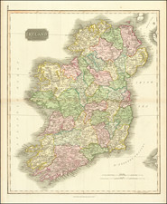
Decorative map of Ireland, from Senex's New General Atlas, first published in 1721.
The map is colored by counties and shows towns, rivers, loughs, islands, etc. Decorative cartouche.
The map is dedicated to Simon Lord Lovat. This map was made 20 years before Lord Lovat changed sides to support the Stuart claim for the crown of the United Kingdom. He was defeated with the Highlanders at the Battle of Culloden and was subsequently tried for treason and beheaded.
John Senex (1678-1740) was one of the foremost mapmakers in England in the early eighteenth century. He was also a surveyor, globemaker, and geographer. As a young man, he was apprenticed to Robert Clavell, a bookseller. He worked with several mapmakers over the course of his career, including Jeremiah Seller and Charles Price. In 1728, Senex was elected as a Fellow of the Royal Society, a rarity for mapmakers. The Fellowship reflects his career-long association as engraver to the Society and publisher of maps by Edmund Halley, among other luminaries. He is best known for his English Atlas (1714), which remained in print until the 1760s. After his death in 1740 his widow, Mary, carried on the business until 1755. Thereafter, his stock was acquired by William Herbert and Robert Sayer (maps) and James Ferguson (globes).
![[ United Kingdom ] Tabula Prima Europae](https://storage.googleapis.com/raremaps/img/small/78537.jpg)
![[Leinster County, Ireland] Comitatus Lageniae -- The Countie of Leinster](https://storage.googleapis.com/raremaps/img/small/23554.jpg)
![[Ireland / Sea Chart] Carte des Cotes Occidentales D'Irlande Reduite de la Carte de Stuart Amos Arnold et rectifee d'apres les Plans leves par M. MacKenzie Publiee Par ordres du Contr-amiral Decres Ministre de Marine et des Colonies . . . 1803](https://storage.googleapis.com/raremaps/img/small/63682.jpg)