


|
||

|

|
|

|
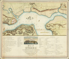
A detailed late-18th century plan of Quebec City, then the capital of British North America.
On this late-18th century map, Quebec City occupies a unique geographical position on a peninsula where the St. Lawrence River and the St. Charles River meet. The Lower Town hugs the banks of the St. Lawrence River, where commercial activities center around the docks and warehouses signifying a busy trade hub.
Ascending from Lower Town, the Upper Town is located atop the steep cliffs of Cape Diamond. Here, the city's layout becomes more structured, with streets organized in something close to a grid pattern, contrasting with the meandering lanes of the Lower Town. This is the administrative and military core of the city, and it's here that the main governmental and military buildings are located.
The map clearly marks out these important structures. The Citadel, with its distinctive star-shaped outline, is prominently featured. As the city's primary defensive structure, it's a visual reminder of British authority and military might. Close by is the Governor's residence, another important symbol of British control.
The various city gates, marked with numbers on the map, punctuate the formidable city walls. Outside these walls, the landscape is sparsely populated, offering a stark contrast to the densely built-up city.
The map's legend or key identifies 28 significant locations in the city, including churches, convents, military installations, and more. Together, these features tell a story of a city under British rule, reflecting its colonial past while illustrating its vital role as a military stronghold and economic center.
![[Boston / Anapolis Royal / Plaisance] Plans des Isles, Rades, et Ports de plusieurs Lieuxde l'Amerique Tires de la Carte Angloises de Mr. Popple publiee en 1733 a Londres en Vingt Feuilles.](https://storage.googleapis.com/raremaps/img/small/85117mb.jpg)
![[ Siege of Quebec ] Quebek, De Hoofdstad van Kanada; aan de Rivier van St. Laurens . . . 1759](https://storage.googleapis.com/raremaps/img/small/93087.jpg)
![[ Quebec ] Profil de la Ville de Quebec et de ses environs attaquee par Les Anglois en L'annee 1691](https://storage.googleapis.com/raremaps/img/small/90028.jpg)