


|
||

|

|
|

|
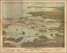
Boston - Anapolis Royal - Plaisance
This is the rare title sheet introducing the first three harbor charts from Henry Popple's 20 sheet map of the British Colonies in North America.
Popple reproduced the harbor charts from Popple's 20 sheet map in a set of 3 sheets. this is the first sheet, with the advertisement.
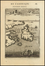
While the map maker is not formally identified, we infer from the initials (PB), the date of the map, the privilege and the address on the map "Quay de la Megisserie au St. Espirit pres le Pont Neuf," that the maker must be Philippe Buache.
This is one of the earliest obtainable maps to incorporate the views from Popple's map.
Rarity
This is the first time we have ever seen this sheet on the market.
Philippe Buache (1700-1773) was one of the most famous French geographers of the eighteenth century. Buache was married to the daughter of the eminent Guillaume Delisle and worked with his father-in-law, carrying on the business after Guillaume died. Buache gained the title geographe du roi in 1729 and was elected to the Academie des Sciences in the same year. Buache was a pioneering theoretical geographer, especially as regards contour lines and watersheds. He is best known for his works such as Considérations géographiques et physiques sur les découvertes nouvelles dans la grande mer (Paris, 1754).

![[Niagara Falls] Cataracte de Niagara](https://storage.googleapis.com/raremaps/img/small/96890.jpg)