|
||

|

|
|

|
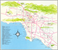
Fine and lively vintage pictorial map of Cannery Village in Newport Beach, produced by the local merchants' association.
The map shows the Pacific Coast Highway at the top and progresses down through the village. Bounded by Newport Blvd, Lafayette Avenue, and 28th Street, this historic center of Newport is shown in vivid pictorial detail. Surrounding the map are various depictions of maritime themes and creatures, including mermaids, sailors, fishermen, pirates, and more.
Cannery Village in Newport Beach has a rich and colorful history that reflects the growth and transformation of the area. In the early 20th century, it emerged as a bustling center for the marine industry, fishing operations, retail stores, and dining establishments, becoming known as Cannery Village. The first fish cannery was built in 1919, and the area saw significant growth with Western Canners expanding in the 1930s. However, the village faced challenges such as pollution and obnoxious odors from the canning operations. Over time, the cannery building was transformed into a restaurant, and the area became home to various businesses, from boat builders to high-class restaurants. Despite losing some of its luster due to eastward development and financial challenges, Cannery Village remains a symbol of Newport Beach's vibrant past.
According to an article by the LA Times, the Lido Shores Hotel closed in the 1970s, thus providing a latest possible date for the map.
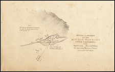
![[ East Los Angeles / Bristow Park ] New Belvedere Gardens and Union Pacific Industrial Tract](https://storage.googleapis.com/raremaps/img/small/97922.jpg)
![(Early Hollywood Photography) [Studio of R.A. Whitten]](https://storage.googleapis.com/raremaps/img/small/97888.jpg)