|
||

|

|
|

|
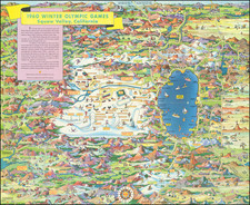
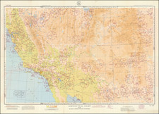
Freeways of the Los Angeles Basin
Interesting Freeway map of the area around Los Angeles.
This map contains information on attractions and routes to take through the LA and Southern California areas. The colorful design and focus on tourist attractions indicate this map's purpose as a visitor's guide to the area.
One of the best features of the map is the scattered cartoons of various attractions available in each area. Notable cartoons on the map include the MGM Lion, Disneyland Castle, and Knott's Berry Farm. These images are accompanied by a sentence of text on the left side that describes what the attraction has to offer. The cartoonish nature of the map continues with the compass, showing a chubby-cheeked, smiling sun with uneven cardinal directions drawn in. The coast includes these cartoons as well, such as a spouting whale by Malibu or a Spanish galleon sailing ship in San Pedro Bay.
The map illustrates roads, although only sparingly. The region's freeways are shown in red, notably with regional names like "Golden State Fwy" instead of Interstate 5. The map also includes major roads in areas, such as Sunset Blvd. and Mulholland Dr as well as some state highways. These roads are illustrated in black with thinner lines to indicate they are not freeways. Surrounding the roads are hills illustrated with a nice green to represent the natural splendor seen throughout Southern California.
A nice view of the stretch of freeway that runs through Los Angeles County. The map offers a pictographic representation of notable activities in the area, making for an interesting piece that highlights the popularity of the area.
![(California-Mexico Border Survey) Datos de los trabajos astronómicos y topográficos. [bound with:] Variedades de la civilizacion, nueva epoca (Tomo I)](https://storage.googleapis.com/raremaps/img/small/70777.jpg)