|
||

|

|
|

|
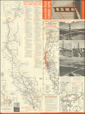
This 1956 map, sponsored by Bekins Van & Storage Co., provides an overview of Palo Alto, Redwood City, Atherton, Mountain View, Menlo Park, San Carlos, Belmont, Los Altos, and Sunnyvale, areas now recognized as the heart of Silicon Valley, California. The inset detailing the regions of San Mateo, Belmont, and San Carlos along with another for Sunnyvale, broadens the cartographic scope, making this map a substantial piece of mid-20th-century Californian cartography.
The period after World War II marked a significant shift in the American socio-economic landscape, largely due to technological advancements and demographic shifts. In the San Francisco Bay Area, these suburban locales began to evolve rapidly during this era, eventually becoming the hub of technological innovation known worldwide today as Silicon Valley. The Bekins Storage Co. map captures these regions on the cusp of transformative change, just before the area's metamorphosis into a global nerve center for technology and innovation.
The Bekins Van & Storage Co., a household name in American moving and storage services during the 20th century, produced this map. Its role as the map's sponsor is indicative of the suburban expansion of the era, a phase bolstered by post-war affluence and the consequent migration to California's burgeoning towns. This connection underlines the map's social-historical relevance, adding a layer of depth to its cartographic value.
![March on the Democratic Convention - Bastille Day Marijuana Parade Saturday, July 14th, 1984. [and] White House Smoke - In](https://storage.googleapis.com/raremaps/img/small/102586.jpg)