|
||

|

|
|

|
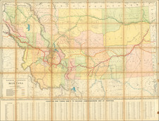
Manuscript Wall Map of Sweet Grass County Drawn By Its First County Surveyor -- Ten Years After Its Founding
Fantastic and previously unknown wall map of Sweet Grass County, Montana, drawn in Big Timber in 1905.
While the map is unsigned, it would seem almost certainly to be the work of Sweet Grass County's first County Surveyor, Derk Jan Walvoord. A similar map is described as surviving in blueprint form in the Montana Historical Society (OCLC: 742003541), as does a smaller map dated 1920 based on Walverood's wall map.
Dirk Walvoord was a surveyor, originally from Wisconsin, where he was born in c. 1867. He emigrated to Big Timber, where he resided at the time of this map's progress. He is cited as the creator of a number of the earliest maps of Sweet Grass County. This appears to be the first of Walvoord's maps, with the later maps acting as blueprints or reductions.
The map divides the county into townships and sections and shows topography, rivers, and more. It shows the layout of Sweetgrass County in its earliest configuration, between the time of its creation on March 4, 1895 and January 1913, when a portion of the county became Stillwater County on March 24, 1913.
Highly detailed, this map shows riveting information, naming many creeks and important geographical features. The Yellowstone Forest Preserve can be seen in the south of the map, with the Absaroka Range and Mt. Douglas named. Big Timber, Grey Cliff, Reed, and Merril are the stops along the Northern Pacific Railroad. The Crazy Mountains appear in the upper left of the map.
Named around the map are Park, Meagher, Carbon, and Yellowstone Counties. Stillwater, Wheatland, and Golden Valley Counties had not yet been formed out of Sweet Grass County, explaining why its boundaries appear different than those of today.
Sweet Grass County is known for its appearance in the 2009 documentary Sweetgrass, which discusses the anthropology of sheepherding in the county.
DJ Walvoord graduated from Hope College in Chicago in 1893.
Walvoord arrived in seems to have moved to Montana in the fall of 1894, where he arrived in Manhattan, Montana, part of an early contingent of Dutch settlers in the region. Favorably impressed, he decided to take a position as a school teacher.
Walvood would be elected Sweet Grass County Surveyor in November 1896 (he received 324 of 326 votes). He was re-elected in 1900, 1902, 1904 and 1906. By 1913, he had been appointed the County Assessor (Big Timber Pioneer, February 20, 1913, Page 3).
In 1908, the Glass Brothers and a group of surveyors and engineers, turned two natural lakes, located in the central portion of Sweet Grass County, into two large reservoirs. Water was from Sweet Grass Creek to create the reservoirs, which fed two irrigation canal systems, which were expected to irrigate approximately 17,000 acres. The upper lake was named Lake Adam for Ed and Emil Adams who sold their ranch to the Glass brothers. The lower lake was named Lake Walvoord in honor of D.J. Walvoord, the head surveyor.
![[Early Montana Territory Shown Above Idaho] Johnson's New Military Map of the United States Forts, Military Posts & all the Military Divisions with Enlarged Plans of the Southern Harbors . . . (Shows Military Departments)](https://storage.googleapis.com/raremaps/img/small/93868.jpg)