|
||

|

|
|

|
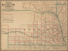
Interesting early Territorial map of the region east of the Rocky Mountains, depicting the early Territorial borders of Kansas Territory, Nebraska Territory and Dakota Territory on the eve of the Civil War.
The map depicts a massive Dakota Territory, extending from the Mississippi River to the Rocky Mountains, which has been carved out of what was previously Nebraska Territory, which now sits between Dakota Territory and Kansas.
While the complete border is not yet given, Colorado Territory is shown, having been established from portions of Kansas Territory and Nebraska Territory following the the 1859 Colorado Gold Rush resulted in the need to create Colorado as a Territory.
The Northern regions on the map are stll relatively unexplored, although an early proposed route for tehe Northern Pacific Railroad is shown, as are numerous Indian Nations and early Western forts.
State of the Map
The early states can be identided as follows:
- State 1: Johnson's Nebraska and Kansas, published by Johnson & Browning in 1860-61. Border for Nebraska follows the Missouri River.
- State 2: Johnson's Nebraska and Kansas, published by Johnson & Browning in 1861. Border for Nebraska now runs more or less due north, increasing the size of Nebraska Territory
- State 3: Johnson's Nebraska, Dakota, Colorado & Kansas, published by Johnson & Browning in 1861-62. Colorado and Dakota aded.
- State 4: Johnson's Nebraska, Dakota, Colorado & Kansas, published by Johnson & Ward in 1862. page 51.
- State 3: Johnson's Nebraska, Dakota, Colorado & Kansas, published by Johnson & Ward in 186-263. Page number changed to 55.
Alvin Jewett Johnson (1827 - 1884) was an American map publisher. Born in Wallingford, Vermont, he received only a basic public education, but he still served as a school teacher for several years before moving to Richmond, Virginia and, in 1857, New York City. Johnson also worked as a book canvasser for the map publisher J.H. Colton.
Johnson's name first appears on maps published with Samuel N. Gaston and D. Griffing Johnson (no clear relation) in the mid-1850s, and his name (along with Ross Browning) appeared on Colton's atlas maps of 1859 and 1860. Although map historian Water Ristow speculates that Colton sold his copyrights to Johnson and his business partner, fellow Vermonter Browning, a more likely theory is that Johnson and Browning financially bailed out the Colton firm in exchange for the right to use Colton’s existing copyrighted map plates. The first Johnson maps were mostly reissues of earlier Colton maps. Indeed, Johnson's earliest works described his firm as the “Successors to J. H. Colton and Company”. Johnson converted the original Colton steel plate engravings to lithographic stones, allowing his firm to produce more maps at a lower price point.
In 1860, the Johnson firm published its first significant work, the Johnson’s New Illustrated (Steel Plate) Family Atlas. The first edition of the Atlas bears imprints in both New York and Richmond, VA. In 1861, however, following the outbreak of the American Civil War, the Johnson & Browning firm abandoned their Richmond location. Browning seems to have remained in Virginia to pursue other ventures and, in 1861, Browning’s portion of the firm was purchased by Benjamin P. Ward. The 1863 issue of the Atlas was one of the most unusual, it being a compilation of older Johnson and Browning maps, updated 1862 Johnson and Ward maps, and newer 1863 maps with a revised border design.
The 1864 issue of the Atlas is the first true Johnson and Ward atlas. Johnson published one more edition in partnership with Ward in 1865, after which Johnson becomes the sole publisher. The next issue of the Atlas, 1866, is the first purely Johnson atlas with all new map plates, updated imprints, and copyrights. Johnson maps include a unique border style, which changed over the years, but was not copied by other makers. These include a “strapwork border” from 1860 to 1863, a “fretwork border” from 1863 to 1869 and a “spirograph border” in 1870.
In addition to the Family Atlas, Johnson issued numerous wall maps, pocket maps, and, in the 1880s, the Cyclopedia. Johnson frequently updated his western atlas maps and on occasion, more than one update appeared in a single year. Johnson continued to publish the Family Atlas until 1887. In 1879, Johnson brought his son into the business, and their publications have the imprint “A.J. Johnson and Son” and, later, “A.J. Johnson and Co.” Johnson’s son continued the business until it shuttered in 1887.