|
||

|

|
|

|
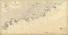
Rare Imperial Japanese Army Map of China
Finely executed large map of China and Korea published in Tokyo just before the outbreak of the Sino-Japanese War. The map was issued by the Imperial Japanese Army General Staff Office (Sanbō-honbu).
The map includes Outer Mongolia, Manchuria, and Taiwan. Taiwan is shown as belonging to China, and the Korean Peninsula has of course not yet been divided into North and South. The Russian border region is shown in detail, while British India includes some place names in Roman letters.
Hachures are used throughout to show elevation and topography, and the river systems are shown, as are railways, major roads, and cities of various sizes. These are detailed in the legend in the bottom left corner. Within China, provinces are separated by dotted lines.
The seas surrounding Asia are filled with bathymetric lines. Major maritime trade routes are marked; they connect ports within China and from China to its neighbors, including Japan.
The title of the map, in four characters of seal script (tenshotai 篆書体), is spread across the four corners of the map. The name of the printer, Utsuki Nobuo 宇津木信夫, is listed vertically in the lower left-hand margin.
Also in the legend at the lower left is a note, dated Meiji 24 or 1891. While the map was drafted in 1891, an inscription in the center of the left margin explains that it was printed and published early in Meiji 25, or 1892. The note in the legend translates to:
This map was primarily made from a comprehensive English map of Asia, as well as a recent Russian map of Central Asia, the Comprehensive Gazetteer of Asia (亜細亜全誌) by the Englishman Mr. Keene (金氏 キーン), a German World Map, and an English unified map of India and China. Its mountains, seas, and rivers are approximated according to the Comprehensive Gazetteer, compensated for by various individual travel records. Place names are according to the unified map [noted earlier] as well as the Shuǐdào tígāng 水道提綱 (a Qing-dynasty gazetteer of rivers). They are translated according to Chinese sound. Those places done according to the writings of Europeans do not appear in Chinese gazetteers.
The note also identifies the proofreader as Army Editing Secretary Shimomura Shūsuke, and the editor as Terrestrial Surveyor Matsumoto Yasushiro. It seems that these army officials used a variety of Western and Asian sources to compile this strategic map.
The style of the map is unusual for Japanese maps of this period. This may be because it was made for the use of the Imperial Japanese Army as they prepared for war with China.
The Sino-Japanese War
By the time this map was published, tensions between China and Japan had been rising for several decades. Upon the resignation of the shōgun Tokugawa Yoshinobu in late 1867, a new government, headed by the Emperor Meiji, was formed on January 3, 1868. This began in a period known as the Meiji Restoration.
Unlike previous leaders, the Emperor and his top officials sought to modernize Japan in order grow Japan’s economy and to gain political respect and equality with their trade partners. Contemporary treaties disadvantaged Japan with respect to European countries, something they sought to remedy but were told could not be renegotiated until Japan reformed its legal institutions. After an initial period focused on domestic development, Meiji officials also began to look outward to establish Japan’s strength regionally and globally.
One of the first examples of this policy was a punitive expedition against Taiwan in 1874. Japan launched the assault as retaliation for the death of Ryukyuan fisherman at the hands of the Taiwanese. The move also strengthened Japan’s claim to the islands, which they incorporated in 1879 over Chinese protest.
The main area where Japan and China came into conflict, however, was the Korean Peninsula. China had long considered Korea a tributary state, while Japan saw it as a possible toehold on the mainland and also coveted their coal and iron deposits. As Japanese influence grew in Korea in the 1880s, both countries came close to open war.
In 1884, pro-Japanese Korean reformers attempted a coup, but it was stopped by Chinese General Yuan Shikai. In response, in 1885, both agreed to the Li-Itō Convention, which decreed that both countries would withdraw their troops and neither would deploy troops in Korea without informing the other.
This map shows that the Japanese had long expected a war and were planning their possible options for years. In 1894, just two years after this map was published, their plans proved prescient. The leader of the 1884 coup, Kim Ok-Kyun, was assassinated in Shanghai by suspected agents of General Yuan Shikai. Kim’s mutilated body was returned to Korea and publicly displayed to quell further rebellion. The Japanese expressed their outrage, but did not yet attack.
Later the same year, the Korean king requested that Chinese troops help to put down the Tonghak Rebellion. The Japanese viewed this as a violation of the 1885 Li-Itō Convention and quickly sent their own troops as a counter-measure. The Chinese tried to send reinforcements, but the Japanese sank the Kowshing, a British steamer carrying the troops; war formally broke out August 1, 1894.
In a surprise to international observers, the Japanese were better prepared and provisioned than the Chinese. Within months, the Japanese had invaded Shandong province and Manchuria, as well as taken fortified posts that oversaw the maritime approach to Beijing. The Chinese decided to seek peace and the combatants negotiated the Treaty of Shimonoseki. China had to recognize Korea as independent, cede Taiwan, the Pescadores Islands, and the Liaodong Peninsula to Japan, pay a substantial indemnity, and give Japan trading privileges.
Although European powers, afraid of Japan’s show of might, forced Japan to return the Liaodong Peninsula to China, the war had succeeded in compelling the world to recognize Japan’s strength and successful modernization efforts. The war weakened China domestically and internationally, leaving Japan as the emergent political and military power in Asia. Japan’s defeat of Russia in the Russo-Japanese War of 1904-5 would only enhance this image. This map, therefore, is part of the larger story of Japanese imperial expansion at the turn of the twentieth century.
Rarity
The map is very rare. OCLC lists only one example at the International Research Center for Japanese Studies.
![[ Taiwan ] Kaart van het Eyland Formosa en de Eylanden van Piscadores . . .](https://storage.googleapis.com/raremaps/img/small/74640.jpg)

![(China) Карта Чжилійской Губерніи No. 1 [Map of the Zhili Province No. 1]](https://storage.googleapis.com/raremaps/img/small/58914.jpg)