


|
||

|

|
|

|
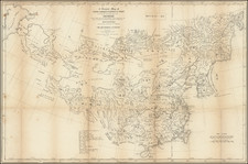
Russia Explores the Possibility of Invading China.
Fascinating Russian-language lithographed map of Zhili Province (the home of Beijing), with inset maps of Beijing, Tongzhou, Kalanga, and Tianjin.
The map was produced in 1871, when there was a very real possibility of war between China and Russia.
The map was the product of a major Russian expedition in China in the 1870s, the focus of which was to learn more about the region and explore the possibility of additional Russian intervention and territorial expansion in China. During this time, the Qing Dynasty was suffering from major internal strife, especially at the territorial periphery, namely due to the Dungan Revolt.
The Dungan Revolt saw the local Dungan people rebel against Han rule in western China, initially successfully. The revolt caused the Qing Dynasty to lose control of Xinjiang at a very opportune time for the Russian Empire, which was completing its conquest of neighboring territories in Central Asia. In 1871, Russia occupied Xinjiang, allegedly for the protection of its citizens and national interests. For a time it seemed that Russia would formally annex Xinjiang and that China might attack Russia because of this encroachment, but in the end with the 1881 Treaty of Saint Petersburg, Russia left Xinjiang and China re-established control.
The map includes a detailed plan of the Forbidden City and Beijing.
Interestingly, the map features a lot of transliteration from Chinese into Russian including in the key and in a separate table which elaborates common Chinese toponyms and gives their Russian equivalent.
The map's key elaborates different sized cities from small up to "Main City of the Province", different kinds of political borders, etc.
![[Shanghai, Hangzhou, Ningbo, Suzhou] Carte du Tche-kiang dressee ar les Missionaires sous la direction de Mgr Guierry de la Congregation de St. Lazare Vicaire Apostque du Tach-Kiang](https://storage.googleapis.com/raremaps/img/small/64426.jpg)
![[Ladrone Islands / Wanshan Archipelago] Ladronen Chine](https://storage.googleapis.com/raremaps/img/small/90221.jpg)
![[Whampoa]](https://storage.googleapis.com/raremaps/img/small/90211.jpg)