


|
||

|

|
|

|
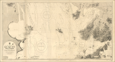
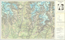
Very rare bilingual (English and Chinese) map of the Shanghai region, focusing on local railroad connections of 1927. The three-stone color lithographed map was made by the Civil Engineer M.H. Chih for the Ming Hao Engineering and Construction Company.
All of the toponyms are given in Chinese and English. In Shanghai itself, the International Settlement, French Concession, and Shanghai Arsenal are all delineated.
The stops on the various lines are enumerated in a table at the right.
A note in the lower left says:
This map shows the railways lying in the richest location of China, and the vicinity of the greatest commercial port in the Far East. It is extremely useful and exceedingly well illustrated. All cities and villages, navigable rivers and famous hills are included. Every body who intends to make a travel should have on in his hands.
OCLC records a 1917 edition owned by Berkeley and Princeton. We find another example of that edition at Stanford. We were unable to find any other examples of the 1927 edition.
![[Nanjing] Nangking](https://storage.googleapis.com/raremaps/img/small/86040.jpg)