|
||

|

|
|

|
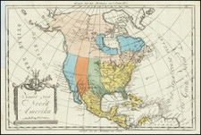
The Final Edition of Aaron Arrowsmith's Map of North America
Fine example of Aaron Arrowsmith's map of North America, one of the seminal maps for the early history of the Transmississippi West.
The present example of Arrowsmith's map is the 1824 edition ....
xxxxxxxxxxxxxxxxxxxxxxxxxx
xxxxxxxxxxxxxxxxxxxxxxxxxx
The 1802 Edition of Arrowsmith's Map
Arrowsmith's 1802 map incorporated several monumental changes not present in the four 1795 editions of the map. For Lewis & Clark, the most notable are those added to the Upper Missouri River regions. The 1802 Arrowsmith was the first to show the Upper Missouri joined with the Mississippi River in its correct location. The ruins of Fort Orleans, built by the French fur trapper and explorer Bourgmont in the early 1700s is shown on the Lower Missouri. The course of the Missouri River, below the Kansas River to the Mississippi, is significantly improved, although above the Kansas River and the Mandan Villages, the Arrowsmith map references "the most Northern Bend of the Missesouri Rios" (an area derived from David Thompson's manuscript map of 1798), but still lacks the information recently obtained by the Spanish / St. Louis fur traders in the preceding decade.
Above and west of the Mandan Villages, the map incorporates for the first time the reports of Peter Fidler for the Hudson's Bay Company, by including a series of possible river courses to the west, leading to (and prospectively through) the Rocky Mountains. It was this section of the map that provided the best depiction of the prospect of a water route or portage through the Rocky Mountains and to the Pacific. It was this information, along with reports from local Indians encountered on the expedition, which Lewis & Clark relied in choosing their path to the Rocky Mountains.
On the far side of the Rocky Mountains, a section of river called the Great Lake River includes a speculative water course which flowed to the River Oregan (Columbia River), included a note stating that "the Indians say they sleep 8 Nights in descending this River to the Sea." This note was one more factor which led to the exploration of this route as a means of a locating navigable route by water to the Pacific Ocean.
The additions and corrections present in the fifth and sixth states of the map, coming from Peter Fidler and the Hudson Bay Company, were the result of Fidler's extensive contacts with the indigenous tribes on the eastern slope of the Rocky Mountains and contributed greatly to the geographical knowledge of the region prior to the return of Lewis & Clark in 1806. The information was transmitted through the Hudson's Bay Company channels back to England and very quickly delivered to Arrowsmith, who was then the primary mapmaker for the HBC.
For a complete discussion of the map, see Warren Heckrotte, "Aaron Arrowsmith's Map of North America and the Lewis and Clark Expedition" in The Map Collector No. 39, Summer 1987.
Lewis & Clark
Both the 1795 and 1802 editions of Arrowsmith's map were used by Nicholas King in his preparation of the primary manuscript map used on the Lewis and Clark Expedition. However, only the 1802 Arrowsmith map (state 5) was carried on the expedition by Lewis & Clark.
As noted by Warren Heckrotte:
On the third of June, 1804, the Lewis and Clark expeditionary party ascending the Missouri River came unexpectedly to "the junction of two large rivers." The information the two captains had obtained from the Minnatree Indians at the expedition's winter camp, Fort Mandan, near the Great Bend of the Missouri had not indicated the presence of a branch of the river at this location. The decision as to which branch was the Missouri was a critical one: the wrong choice "might defeat the expedition altogether." For the next week the captains reconnoitered the two branches. By June 10 they had decided the south branch was the Missouri. Lewis set out ahead of Clark to search for the critical text -- the Great Falls of the Missouri. On June 13 he found them . . .
DeVoto calls the reasoning of the two captains at this juncture a remarkably act of the mind that should occupy a distinguished place in the history of thought.
In their considerations the captains brought to bear the great map of North America by Aaron Arrowsmith. . . .
In making this critical decision, Arrowsmith's map was the focal point. As noted by Heckrotte:
On June 8 the journal of the expedition summarized their assessment of the relevant portions of Arrowsmith's map. Lewis believes from the map that [Peter] Fidler had descended along the eastern side of the Rocky Mountains to the "remarkable mountain" called the "Tooth" at latitude 46º north and that Fidler had not seen the Missouri on the journey, "only small streams coming down from the mountains." The captains reasoned that Fidler could not have come so far south without meeting the great river and concluded that Fidler and the map were in major error in this region.
The 1814 Edition
A second edition of the map was issued in 1802, adopting additional information from Peter Fidler. Thereafter, the next edition of the map was issued in 1811. As noted by Rumsey:
This issue is the seventh (Heckrotte) and makes changes to the Canadian waterways, when compared to the 1802 editions. The American West has been largely unchanged since the first issue of 1795. In the next issue (1814) there are massive changes in the American West.
Beginning with the 1814, edition, Arrowsmith makes a massive leap forward, introducing the breakthrough cartographic content derived from Lewis & Clark, Alexander Humboldt, Pike and others. What had previously been a little known a largely blank canvas west of the Mississippi River is radically transformed, with extensive hydrographic details, mountains, Indian Settlements and far better understanding of the Rocky Mountains and various other primary Mountains ranges of the mid-continent.
It may fairly be stated that prior to John Melish's map of 1816, which would not appear for another 2 years, Arrowsmith's 1814 map, more than any other, offered the first glimpses of the full extent of America's "Manifest Destiny," a term still not yet born, but very much a part of the Jeffersonian and later Jacksonian visions for America.
Editions of the Map
Arrowsmith's map was published in a number of editions between 1795 and 1824, with the later editions by his son John Arrowsmith in 1833 and 1839.
The present state is the only edition issued between 1811 and 1817 and bears note below the title that it includes "Additions to June 1814."
Rarity
The Arrowsmiths were a cartographic dynasty which operated from the late-eighteenth century to the mid-nineteenth. The family business was founded by Aaron Arrowsmith (1750-1823), who was renowned for carefully prepared and meticulously updated maps, globes, and charts. He created many maps that covered multiple sheets and which were massive in total size. His spare yet exacting style was recognized around the world and mapmakers from other countries, especially the young country of the United States, sought his maps and charts as exemplars for their own work.
Aaron Arrowsmith was born in County Durham in 1750. He came to London for work around 1770, where he found employment as a surveyor for the city’s mapmakers. By 1790, he had set up his own shop which specialized in general charts. Arrowsmith had five premises in his career, most of which were located on or near Soho Square, a neighborhood the led him to rub shoulders with the likes of Joseph Banks, the naturalist, and Matthew Flinders, the hydrographer.
Through his business ties and employment at the Hydrographic Office, Arrowsmith made other important relationships with Alexander Dalrymple, the Hudson’s Bay Company, and others entities. In 1810 he became Hydrographer to the Prince of Wales and, in 1820, Hydrographer to the King.
Aaron Arrowsmith died in 1823, whereby the business and title of Hydrographer to the King passed to his sons, Aaron and Samuel, and, later, his nephew, John. Aaron Jr. (1802-1854) was a founder member of the Royal Geographical Society (RGS) and left the family business in 1832; instead, he enrolled at Oxford to study to become a minister. Samuel (1805-1839) joined Aaron as a partner in the business and they traded together until Aaron left for the ministry. Samuel died at age 34 in 1839; his brother presided over his funeral. The remaining stock and copper plates were bought at auction by John Arrowsmith, their cousin.
John (1790-1873) operated his own independent business after his uncle, Aaron Arrowsmith Sr., died. After 1839, John moved into the Soho premises of his uncle and cousins. John enjoyed considerable recognition in the geography and exploration community. Like Aaron Jr., John was a founder member of the RGS and would serve as its unofficial cartographer for 43 years. Several geographical features in Australia and Canada are named after him. He carried the title Hydrographer to Queen Victoria. He died in 1873 and the majority of his stock was eventually bought by Edward Stanford, who co-founded Stanford’s map shop, which is still open in Covent Garden, London today.
![[ US-Mexico Border Survey: General Order From the President of the United States Directing William H. Emory to lead the US-Mexico Boundary Survey ]](https://storage.googleapis.com/raremaps/img/small/101837.jpg)
![[Separately Published Example!] Map of the United States of America. Designed to illustrate the Geological Memoir of Wm. Maclure Esq.](https://storage.googleapis.com/raremaps/img/small/90048.jpg)