|
||

|

|
|

|
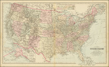
Early Appearance of the Michigan Territory and Ohio -- One of the Maps Consulted By Lewis & Clark
Fine full-color example of Aaron Arrowsmith's landmark map of the United States, published shortly after the Louisiana Purchase.
The map contains fabulous details regarding the eastern seaboard, inland to the Mississippi. The map is particularly remarkable for its detail in the Trans-Appalachian region, which draws on detail from various American sources. Further west, detail becomes sparser, and the Mississippi River and its tributaries provide the only detail in the region.
The map shows representations of the Mississippi Basin region that are starting to be updated from French 18th-century sources. The uppermost Mississippi has a number of tributaries and feeding lakes, and a portage system is shown between the Mississippi and the tributaries for the Lake of the Woods. Dividing ranges are shown here.
This is the first state of the map to name Michigan and Ohio. Detroit and French Town and forms part of a general trend in Arrowsmith's mapping to increase the information available in the plains and midwestern states. This area started in the earliest editions as having information limited only to the river regions, and by later editions evolved to having a comparable amount of information across the map.
Arrowsmith displays his mastery of cartography in the Tennessee and Kentucky regions, where detail is updated well past what Mitchell's and Pownall's maps showed. This relied on early American reports of exploration in the region, which commenced as soon as the Revolutionary War ceased. Arrowsmith likely relied on an early state of Bradley's Map of the United States for some of the updated information. For information further north and west, Arrowsmith incorporated information using the data passed to the by fur traders and Native Americans for the Hudson Bay Company.
This map appeared alongside another Arrowsmith map of the interior parts of the continents which was the most accurate map of the western United States at the time and used by the Lewis and Clark Expedition during their travels.
In addition to ground-breaking cartography, the map is embellished with a large, engraved vignette of Niagara Falls with descriptive text describing the falls. Two blocks of text describe this waterfall.
States of the Map
The map is known in the following states:
- 1796: Arrowsmith address-Charles Street. Tennassee Government shown. Includes "Boundaries Communicated by Geo. Chalmers Esq.r"
- 1796 circa: "Tennassee" added as a state, but the address is unchanged. (Note that this is not what is described by Stevens & Tree.)
- 1799 circa: Address now 24 Rathbone Place.
- 1802: Imprint line on lower left sheet reads "London Jan. 1st 1796. Additions to 1802":
- 1804 circa: Chalmers' text block deleted (bottom left corner)
- 1808 circa: address changed to 10 Soho Square.
- 1810 circa: Arrowsmith given title 'Hydrographer to H.R.H. the Prince of Wales ...',
- 1810 circa: Michigan and Ohio Territories added for the first time.
- 1815: imprint changed to "Additions to 1802-1815."
- 1818: imprint changed to "Additions to 1802-1816."
- 1818: Imprint Changed to "Additions to 1802-1818."
- 1819: Imprint Changed to "Additions to 1819" Northwest Territory, Indiana, Louisiana, Illinois Territory, Missouri Territory and Mississippi Territory are added.
- 1819: Wing flaps added to the map to cover additional area outside the neatlines of the 4 sheets.
Rarity
Arrowsmith's map of the United States is scarce on the market, especially the pre-1808 editions of the map, pre-dating Arrowsmith's move to Soho Square.
The Arrowsmiths were a cartographic dynasty which operated from the late-eighteenth century to the mid-nineteenth. The family business was founded by Aaron Arrowsmith (1750-1823), who was renowned for carefully prepared and meticulously updated maps, globes, and charts. He created many maps that covered multiple sheets and which were massive in total size. His spare yet exacting style was recognized around the world and mapmakers from other countries, especially the young country of the United States, sought his maps and charts as exemplars for their own work.
Aaron Arrowsmith was born in County Durham in 1750. He came to London for work around 1770, where he found employment as a surveyor for the city’s mapmakers. By 1790, he had set up his own shop which specialized in general charts. Arrowsmith had five premises in his career, most of which were located on or near Soho Square, a neighborhood the led him to rub shoulders with the likes of Joseph Banks, the naturalist, and Matthew Flinders, the hydrographer.
Through his business ties and employment at the Hydrographic Office, Arrowsmith made other important relationships with Alexander Dalrymple, the Hudson’s Bay Company, and others entities. In 1810 he became Hydrographer to the Prince of Wales and, in 1820, Hydrographer to the King.
Aaron Arrowsmith died in 1823, whereby the business and title of Hydrographer to the King passed to his sons, Aaron and Samuel, and, later, his nephew, John. Aaron Jr. (1802-1854) was a founder member of the Royal Geographical Society (RGS) and left the family business in 1832; instead, he enrolled at Oxford to study to become a minister. Samuel (1805-1839) joined Aaron as a partner in the business and they traded together until Aaron left for the ministry. Samuel died at age 34 in 1839; his brother presided over his funeral. The remaining stock and copper plates were bought at auction by John Arrowsmith, their cousin.
John (1790-1873) operated his own independent business after his uncle, Aaron Arrowsmith Sr., died. After 1839, John moved into the Soho premises of his uncle and cousins. John enjoyed considerable recognition in the geography and exploration community. Like Aaron Jr., John was a founder member of the RGS and would serve as its unofficial cartographer for 43 years. Several geographical features in Australia and Canada are named after him. He carried the title Hydrographer to Queen Victoria. He died in 1873 and the majority of his stock was eventually bought by Edward Stanford, who co-founded Stanford’s map shop, which is still open in Covent Garden, London today.
![Colton's United States of America [State of Colona named]](https://storage.googleapis.com/raremaps/img/small/90086.jpg)
![[Hand Drawn Map] Le Golfe de Mexique avec les Pays Circonvoisins](https://storage.googleapis.com/raremaps/img/small/91580.jpg)