Search
William Barnard Clarke was a multifaceted Englishman renowned for his numerous contributions in the realms of architecture, cartography, archaeology, and the arts. Born in 1806, his profound influence extended across various domains, making him one of the distinguished personalities of his time.
As an architect, in 1831, Clarke played a pivotal role in the founding of the Architectural Society of London and served as its inaugural president.
Clarke was a mapmaker of note, especially for his association with the Society for the Diffusion of Useful Knowledge (SDUK). Established in 1826, the Society aimed to make knowledge accessible to a broader audience, and Clarke's contributions played a significant role in that mission.
Clarke's initial work for the Society in 1830 was a Celestial Atlas, a set of six maps that detailed the stars. These maps amalgamated information from scientifically-informed sources and were supervised by Sir John Lubbock. They were lauded not only for their exemplary execution but also for being reasonably priced, resonating with the Society's ethos of wide dissemination.
By this time, Clarke had garnered recognition as a proficient artist-draftsman. Over the subsequent decade, he dedicated himself to crafting a series of European city maps. While these weren't original surveys, Clarke's dedication saw him frequently traveling to authenticate specific details. These maps were also adorned with architectural views and cameos, usually positioned at the bottom of each sheet.
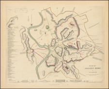
A highlight among his works was the "Plan of Ancient Rome," engraved by J. and C. Walker and released in 1830. This map was accompanied by a complementary "Plan of Modern Rome." Clarke's repertoire also included detailed plans of European cities like Warsaw, Milan, Frankfurt am Main, Berlin, Turin, Paris, St Petersburg, London, Florence, Genoa, Venice, Amsterdam, Moscow, Copenhagen, and Stockholm throughout the early 1830s. Clarke's meticulous plans and maps, renowned for their precision and detail, remain collectible items to this day.
While primarily known for his mapmaking prowess, Clarke's architectural skills are evident in his Guide to Hayling (1836), showcasing Hayling Island in Hampshire as an emerging tourist destination. The illustrations, with architectural nuances similar to those in his city plans, were notably his handiwork.
Clarke's profound interest in archaeology is also reflected in his work on Pompeii. He collated materials for a two-volume work on the excavations at Pompeii, initially published in 1831-1832, and then republished in 1836. The work was later translated into German and published in Leipzig. Clarke's dedication to Pompeii didn't end with his writings. His personal collection was enriched with artifacts from the site, revealing his fascination with the ancient city.
By around 1840, Clarke's contributions to the SDUK seemed to wane. Subsequently, his travels led him to Italy, where he indulged in collecting art, sculptures, coins, and medals. He traveled extensively, visiting Switzerland, the Netherlands, and parts of Germany, further augmenting his collections.