
The item illustrated and described below is sold, but we
have another example in stock. To view the example which
is currently being offered for sale, click the
"View Details" button below.


|
||

|

|
|

|
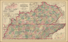
Stock# m0344
Description
Stunning large format map of the two states, hand colored by county and showing remarkable details for the period. Inset maps including a rail system and population density chart. Perhaps the best commercial atlas map of the period. Gray's National Atlas was one of the most successful commercial ventures of the 1870s and one of the last to employ hand coloring on maps.

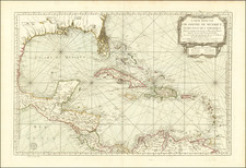


![La Florida [with] Guastecan [with] Peruviae Avriferae Regionis Typus](https://storage.googleapis.com/raremaps/img/small/89451.jpg)