|
||

|

|
|

|
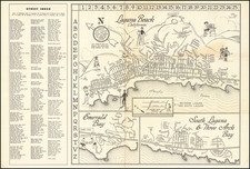
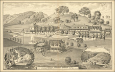
This 1926 map of Santa Barbara County, California, produced by The Kenyon Co., Inc., Map Makers of Des Moines, is a detailed color-lithographed representation of the area, remarkable for its clarity in depicting Old Spanish Land Grants. The map includes an inset of an enlarged portion of the city of Santa Barbara and its adjacent territories. It provides a comprehensive view of the area’s transportation networks and land divisions.
In the 1920s, Santa Barbara County was undergoing significant changes, reflecting the broader trends of development and modernization in California. This period was marked by the growth of infrastructure, including the expansion of state highways and the differentiation of roads by their construction and utility (paved, secondary, common, and trails). The map's detailed illustration of these features offers a snapshot of the county's evolving transportation landscape, highlighting the interaction between urban and rural environments in early 20th-century California.
The inclusion of Old Land Grants in the map is particularly noteworthy. These grants, remnants of Spanish and Mexican land divisions before California's statehood, provide a unique historical layer to the map. Their presence serves as a geographical marker and a testament to the complex and multi-layered history of land ownership and usage in the region, reflecting the transitional period between traditional landholding practices and modern property delineations.