|
||

|

|
|

|
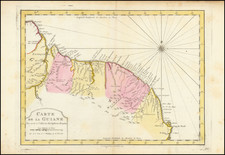
Detailed snapshot of the colonial division of Guyana between the French and Dutch at the end of the 18th Century.
The map shows the territorial claims of these two South American colonial possessions.
Guyana, situated on the northeast coast of South America, was an area of strategic importance and agricultural potential in the 18th century. The French and Dutch, along with other European powers, were drawn to this region for its resources and strategic location. The map from 1795 captures this moment of colonial competition and presence in the area.
The French colonies in Guyana, as represented on the map, were primarily focused on agricultural production. Plantations, reliant on enslaved labor, were established to cultivate crops such as sugar and coffee. This aspect of French colonial activity was part of a broader Atlantic slave trade, which had profound and lasting impacts on the region's demography and culture.
Similarly, the Dutch had established their presence in the region much earlier, with their settlements dating back to the early 17th century. The Dutch influence in Guyana was notable in terms of agricultural development and economic activity. Like the French, the Dutch also operated plantations with enslaved labor, contributing to the complex societal structure in the colonies.
![[ El Dorado! ] Guiana in Guianam & Caribanam divisa. Per N. Sanson](https://storage.googleapis.com/raremaps/img/small/97909.jpg)
![[French Guiana] Pas-kaart Van de Zee-kusten van Guiana Tusschen Cabo Noord en Rio Amano . . . (Inset maps of Fort van Cajana and I. Cayana)](https://storage.googleapis.com/raremaps/img/small/55190.jpg)