|
||

|

|
|

|
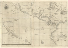
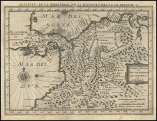
Detailed map of the northern part of South America, detailing the geopolitical outcomes in the wake of the Latin American wars of independence. It encompasses the territories of New Granada, Venezuela, Ecuador, and the Guianas, capturing a snapshot of the newly-formed republics and their boundaries post-independence.
New Granada, after a series of revolts beginning on July 20, 1810, achieved its de facto independence with the victory at the Battle of Boyacá on August 7, 1819, under the leadership of Simón Bolívar and Francisco de Paula Santander. This territory would later fragment, with Ecuador separating after the dissolution of Gran Colombia in 1830, a federation which had briefly united several former Spanish colonies.
Venezuela, once part of Gran Colombia, declared independence from Spanish rule on July 5, 1811. However, it faced reconquest until the Battle of Carabobo on June 24, 1821, ensured its liberation. José Antonio Páez played a crucial role in both the battle and the subsequent establishment of Venezuela as a sovereign state.
Ecuador marked its entry into independence with the Battle of Pichincha on May 24, 1822, where Antonio José de Sucre was pivotal in defeating the Spanish forces, leading to Ecuador joining Gran Colombia until its secession in 1830.
The Guianas, portrayed on the eastern margins of the map, contrast the independence of their neighbors, remaining under European colonial dominion: the British Guiana, Dutch Guiana, and French Guiana, each demarcated and labeled, signifying ongoing colonial presence.
This map serves as an artifact of its time, detailing the complex process of nation-state formation and the establishment of boundaries that would define the political landscape of South America. It is an invaluable resource for understanding the historical geography of the region during a period of significant transition and transformation.
Beginning in the early 19th Century, Lapie was one of the leading French mapmakers, at a time when much of the great exploration and travel literature was being published in French. Lapie was often the engraver of maps which were included in these books. As a result, he often incorporated the most recent information and discoveries in his maps, often appearing prior to the official report from which the information derived. His maps are now prized for their detail, accuracy and attractive engraving style.