|
||

|

|
|

|
The First Map of Bosnia in Fine Original Color
An extraordinary example of this rare separately published map of Bosnia & Herzagovina, published in Vienna by Etienne Briffault.
An exceptional separately published map of Bosnia, published in the midst of the Austro-Turkish War (1737-1739), with a dedication to Field Marshal Ludwig Andreas von Khevenhüller. Produced in Vienna by Etienne Briffaut at the conflict's zenith, this map would have been reserved for high-ranking officers due to their portability and ease of use in the field. The scarcity of such items, combined with the remarkable preservation of this specimen, underscores its collectible significance.
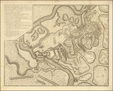
Reflecting the era's most advanced cartographic standards, the map offers meticulous detail attributed to the surveys of Austrian engineers, possibly informed by Johannes Weingartner's earlier works. Covering the region from Krka in Slovenia to Belgrade, it provides strategic information including post stations, roads, and military positions from the early war period.
The map details the geographical features and transportation routes in the region of Metohija, delineated from Albania by the White Drim river and the Prokletije mountains. Key locations along these routes include significant towns and settlements such as Dečani, Peć, Mitrovica, and Priština, with Peć noted for its historical significance as the seat of the Serbian Patriarch. The lack of contemporary data required reference to Ptolemy’s ancient charts for information on the border settlements between Serbia and Albania.
Attention to the transportation network is evident, with several key roads depicted: the via Drine connecting Pljevlja to Peć; a route from Herzegovina through Plav to the Albanian border; and a third road linking Višegrad, Nova Varoš, and Novi Pazar with Mitrovica and Priština. Additionally, a transversal road from Mitrovica to Podujevo is shown. The map's precision in marking various topographical features such as fortresses, cities, towns, marketplaces, monasteries, and navigable rivers highlights its strategic importance. The double lines signifying navigable rivers further emphasize the map’s focus on thoroughness and accuracy, critical for military planning during the period.
Khevenhüller, appointed as commander of the Habsburg forces in 1736 and notable for his victory at the Battle of Radujevac, is the map's dedicatee. Briffaut likely printed only a small number of these maps, intended for the marshal and his top aides. This war, a sequel to the 1714-1718 conflict where the Habsburgs initially gained significant ground including Belgrade and parts of Serbia, did not end favorably for Austria. The subsequent Treaty of Belgrade in 1739 reversed many gains, a geopolitical shift that Briffaut incorporated into a later edition of the map in 1740.
Little is documented about Briffaut's life, but he is known to have been a publisher and bookseller in Vienna, as well as a small number of very rare maps covering parts of the Balkans and Eastern Europe. His military maps, reflecting the Austro-Turkish War's theaters, were limited editions aligning with the exclusive nature of his enterprise.
The map celebrates the recent defeat of the Ottoman Empire in the region, led by Ludwig Andreas Khevenhüller, Graf von Aichelberg-Frankenburg (the Count of Khevenhüller)- 1683-1774), an Austrian field-marshal who came of a noble family that was originally from Franconia and had settled in Carinthia. In 1737 Khevenhüller was made Field Marshal, Prince Eugene recommending him to his sovereign as the best general in the service. His chief exploit in the Turkish War, which soon followed his promotion, was at the Battle of Radojevatz (September 28, 1737), where he cut his way through a greatly superior Turkish army. The map dedication specifically references this battle.
The full title of the map is:
Le Royaume de Bosnie, dans son entier, dédié à Son Excellence Monseigneur le feld-maréchal Comte de Khevenhüller, Colonel d'un Régiment de Dragons, vice-Roi du Royaume d'Esclavonie, du Duché de Syrmie, et Gouverneur de la forteresse d'Osijek etc. Je me suis fait un devoir de publier cette Carte sous les auspices de Votre Excellence, étant un des Capitaines de Sa Majesté Impériale et Catholique; qui entend mieux le métier de la guerre, et qui marche sur les mêmes principes que le défunt Prince Eugène, ayant le même zèle et la prudence comme elle en a donné des preuves par les dernières campagnes d'Italie, et en dernier lieu par le combat contre les troupes Ottomanes arrivé le 28 septembre 1737 près de la rivière de la Timok, et suis avec un parfait dévouement et un profond respect de Votre Excellence le très humble et très obéissant Serviteur. Etienne Briffault librairde a Vienne.
The title translates in relevant part:
The Kingdom of Bosnia, in its entirety, dedicated to His Excellency Field Marshal Count Khevenhüller, Colonel of a Regiment of Dragoons, Viceroy of the Kingdom of Slavonia, of the Duchy of Srem, and Governor of the fortress of Osijek etc. I have made it my duty to publish this Map under the auspices of Your Excellence, being one of the Captains of His Imperial and Catholic Majesty; who understands the art of war better, and who follows the same principles as the late Prince Eugene, having the same zeal and prudence as he has proven in the latest campaigns in Italy, and most recently by the battle against the Ottoman troops on September 28, 1737, near the Timok River . . .
The text box translates as follows:
An original and particular map of Bosnia in its entirety, the first given to the public. To this day, we have never had any particular map of this famous Province so renowned, which has made so much noise in the World for several centuries. with Croatia, Slavonia, Morlachia, parts of Hungary, Styria County of Cilley, Carinthia, Carniola, parts of the Maritime Borders, parts of Dalmatia, Serbia, and Albania. With the boundaries and bodyguards of the national militia of His Majesty and c. from Ratzka to the river Una, along the Sava, and on the other side of said river in Bosnia the Borders settled by the Peace of Passarowitz between His Majesty and that Grand Lord, with the bodyguards proud, from the river Drin to the river Una, with the march and counter-march of the Imperial army in Bosnia by the most serene Prince Eugene for the execution of the seraglio Capital of the Kingdom of Bosnia.
In Vienna, Austria at Etienne Briassaut Bookseller 1738.
With Grace and Privilege of the Holy and Catholic Majesty.
Rarity
The map is extremely rare.
We note an example printed on silk, offered by Dasa Pahor and subsequently by Daniel Crouch Rare Books.
OCLC locates examples at the Badische Landesbibliothek and Bibliotheque National de France.
We also note examples at the Hungarian Military History Institute and Museum.
![[ Serbia / Bosnia / Croatia ] Tabula Geographica exhibens Regnum Sclavoniae cum Syrmii Ducatu . . . MDCCXXXXV](https://storage.googleapis.com/raremaps/img/small/74757.jpg)
![[ Istria, Sloveniam, Northern Croatia ] Karstia, Carniola Histria et Windorum Marchia](https://storage.googleapis.com/raremaps/img/small/95562.jpg)
![[Bar, Montenegro] Antiveri Citta in confine della Dalmatia et Albania . . .](https://storage.googleapis.com/raremaps/img/small/75702.jpg)