|
||

|

|
|

|
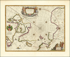
First state of Hondius' decorative map of the South Polar region, predating the first appearance of New Zealand and Van Diemen's Land from the 1638 Latin edition of the Hondius-Jansson Atlas Novus.
The map shows all but two of the known Dutch discoveries up to 1627, including those of Pieter Nuyts, Frederick de Houtman, Dirk Hartog, and Jan Fransz's Leeuwin south of the 20th parallel south. Omitted are the voyages of Jansz and Roossengin in 1605-06 and Cartensz and van Colster in 1623. Gerritt Frederikszoon de Witt's explorations in 1628 are also absent. Saint Helena, the Disappointment Islands, and Le Maire's discovery of the Tongan archipelago, all above the 20th parallel, are shown outside the circular perimeter. The supposed coastline of the unknown southern continent appears as a splintered, hachured line, nearly touching Tierra del Fuego. Includes notes regarding the affirmation of the discovery of islands by Magellan and Hernando Gallego. Vignettes filling the four corners purportedly depict various native scenes spanning the region.
The supposed coastline of the unknown southern continent continues to appear. Nice detail in Australia showing t' Lant van P. Nuyts discovered in January 1627, Edel's Lant discovered in 1619, Eendrachts discoveries in 1616, as well as notes mentioning Williams Renier and Dirck Hertogs Ree and several other place names and early contacts with Australia.
Includes notes regarding the affirmation of the discovery of islands by Magellan and Hernando Galego.
Includes the blank dedication cartouche.
Henricus Hondius (1597-1651) was a Dutch engraver and mapmaker, a member of a prominent cartographic family. His father, Jodocus Hondius, was also an engraver and geographer. While working with his father, Henricus was instrumental in the expansion and republishing of Mercator’s atlas, first published in 1595 and republished by Hondius in 1606.
Upon his father’s death in 1612, Henricus and his brother, Jodocus the Younger, took over the business. He set up his own shop in 1621, where he continued to release new editions of the Mercator atlas. Later, he partnered with his brother-in-law, Jan Janssonius, in continuing to expand and publish Mercator’s atlas, which would become known as the Mercator-Hondius-Janssonius atlas. Born and based in Amsterdam, he died there in 1651.
![[Tasmania] Van-Dieman's Land](https://storage.googleapis.com/raremaps/img/small/71538.jpg)