|
||

|

|
|

|
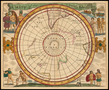
Fine example of Augustus Petermann's map of "The Discoveries of the American North Polar Expedition under Captain C.F. Hall 1871-1873, with a Sketch of the Discoveries of the English Expedition under Captain Nares 1875/6."
Petermann's map encapsulates the charting of two significant voyages of Arctic exploration from the late 19th century, delineating the territories charted and the nautical routes taken.
Captain Charles Francis Hall's expedition, which took place between 1871 and 1873, was one of the earliest American efforts to reach the North Pole. Hall was not a formally trained explorer but was driven by a passion for Arctic exploration and the fate of previous expeditions. His journey, marked by the use of the ship Polaris, was both groundbreaking and tragic, as it led to significant discoveries in the far north regions but was also marred by Hall's untimely death under mysterious circumstances in 1871, possibly due to poisoning.
The Nares Expedition, led by British naval officer George Strong Nares, occurred shortly after, from 1875 to 1876. Nares commanded two ships, the HMS Alert and HMS Discovery, with the aim of reaching the North Pole via Smith Sound. The mission was noted for its scientific approach and extensive use of sledges to conduct surveys. While the expedition did not reach the North Pole, it achieved the farthest northward penetration at that time, setting a record that stood for decades.
The map itself likely serves as a geographical synthesis of these two ventures, showcasing the respective paths and discoveries made by each expedition. It probably features various Arctic landmarks, including Greenland, Baffin Bay, and the numerous smaller islands and waterways that constitute the Arctic archipelago. The locations such as "Grinnell Land," "Smith Sound," and "Robeson Channel" are significant for they were focal points of these explorations.
August Heinrich Petermann (1822-1878) is a renowned German cartographer of the nineteenth century. Petermann studied cartography at the Geographical Art-School in Potsdam before traveling to Edinburgh to work with Dr. A. Keith Johnston on an English edition of Berghaus’ Physical Atlas. Two years later he moved to London, where he made maps and advised exploratory expeditions as they set off to explore the interior of Africa and the Arctic.
In 1854, Petermann returned to Germany to be Director of the Geographical Institute of Justus Perthes in Gotha. There, he was the editor of the Geographische Mittheilungen and Stieler’s Handatlas. The Royal Geographical Society of London awarded him their Gold Medal in 1860. He continued his interest in exploration in Germany, fundraising for the German Exploring Expeditions of 1868 and 1869-70, which sought an open Arctic sea. Tragically, he committed suicide in 1878.
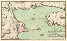
![[Quebec] Profil de la Ville de Quebec et de ses environs attaquee par Les Anglois en L'annee 1691](https://storage.googleapis.com/raremaps/img/small/90028.jpg)