|
||

|

|
|

|
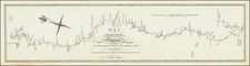
This 1900 manuscript map offers a detailed representation of Galveston Bay and the San Jacinto River, as well as the vicinity of modern-day Houston, as surveyed under the supervision of Captain C.S. Riché of the U.S. Army Corps of Engineers. Drafted by H.J. Condron, this original map on drafting linen provides a unique perspective on the area, oriented with northeast at the top.
The late 19th and early 20th centuries were pivotal in the development of cartographic techniques and geographical knowledge in the United States. The mapping of Galveston Bay, a critical component of Texas's coastal geography, occurred during this period of enhanced surveying activity. It reflects both the technological advancements in cartography and the increasing importance of accurate geographical data for military and civilian purposes. The use of triangulation, a method crucial for precise land surveying, is a significant feature of this map, marking a transition from rudimentary to more scientific and reliable mapping methods.
Rich in detail, the map delineates various landmarks used for the triangulation survey, such as "Battlefield," "Santa Anna," "Morgna's Point," and "Cedar Pt.," among others. These references assist in understanding the topography and serve as historical markers, offering insights into the region's past. The inclusion of sites like "Battlefield" and "Santa Anna" evokes the area's rich history, particularly its role in the Texas Revolution and the Battle of San Jacinto.
The map, with Buffalo Bayou on the left and Upper Galveston Bay to the right, allows for an in-depth study of this significant Texas coastline. The map's orientation, with northeast at the top, is an intriguing choice, deviating from the more common north-oriented maps, thereby providing a unique view that highlights different aspects of the region's geography.
![Carta geografica della Florida nell'America settentrionale [Geographical map of Florida in North America]](https://storage.googleapis.com/raremaps/img/small/84142.jpg)
![[ Republic of Texas ] Central America II. Including Texas, California and the Northern States of Mexico](https://storage.googleapis.com/raremaps/img/small/93534.jpg)