|
||

|

|
|

|
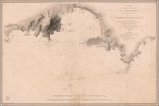
Willem Blaeu's edition of the Jodocus Hondius II map of the Straits of Magellan, Le Maire Strait, Fire Lands and the southern tip of Patagonia.
The map is one of the earliest obtainable atlas maps of the straits, preceded only by a map published by Jodocus Hondius in 1606, with the present map significantly revised and improved.
The map is not to be confused with the later and completely revised map of the Straits of Magellan, published by Blaeu after 1634, which was used only briefly by Blaeu, before creating his own map of the Straits of Magellan circa 1635.
Blaeu's map is essentially the third state of the Hondius map, with the name re-engraved. The Hondius, in turn, is known in a proof state (unrecorded) and a state which is essentially identical to the Blaeu, except for the name change.
By contrast, the proof state does not include the text annotation to the left of the Patagonian man below the compass rose, lacks the rings around the two sets of text annotations below and to the left of the compass rose, lacks the mountains above and to the right of the compass rose and lacks the mountains to the right of the Notitia cartouche. In the proof state, the west side of Tierra del Fuego and regions above are shown as small islands, rather than the ambiguous forms used in the later Hondius map. The notes in the center of the map are contained in small circles in the earlier edition and a massive Patagonian is shown next to a smaller European man at the bottom center, along with two sea lions. Nassauvsche Voerd and Lheremitens Eylandt and Cape Horn appear on the later edition of the map only, whereas no island or strait above Cape Horn appears in the early edition. The contours of the southern coastline are also completely different. The placement of the compass rose is also moved.
States
A link to the proof state can be found here.
All states of the map are quite rare.
Willem Janszoon Blaeu (1571-1638) was a prominent Dutch geographer and publisher. Born the son of a herring merchant, Blaeu chose not fish but mathematics and astronomy for his focus. He studied with the famous Danish astronomer Tycho Brahe, with whom he honed his instrument and globe making skills. Blaeu set up shop in Amsterdam, where he sold instruments and globes, published maps, and edited the works of intellectuals like Descartes and Hugo Grotius. In 1635, he released his atlas, Theatrum Orbis Terrarum, sive, Atlas novus.
Willem died in 1638. He had two sons, Cornelis (1610-1648) and Joan (1596-1673). Joan trained as a lawyer, but joined his father’s business rather than practice. After his father’s death, the brothers took over their father’s shop and Joan took on his work as hydrographer to the Dutch East India Company. Later in life, Joan would modify and greatly expand his father’s Atlas novus, eventually releasing his masterpiece, the Atlas maior, between 1662 and 1672.
![[Arctic Sea] Mari Arcipelaghi polari artici Dalla Baia D'Hudson all America Russa](https://storage.googleapis.com/raremaps/img/small/65899.jpg)