|
||

|

|
|

|
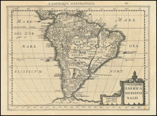
Dedicated To John Narborough
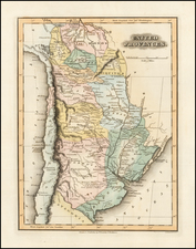
Rare English sea chart of the southern part of South America, which appeared in Seller's Atlas Maritimus.
The map provides a detailed, if somewhat inaccurate depiction of the Rio de la Plata and its lower tributaries, with the Rio Paragua extending well into the central part of the continent. The outline of the continent seems to match Sanson's Le Paraguay R. Le Chili. La Terre, et Ls Isles Magellanicques. . . . 1656.
The map includes a "De G. Brewer's Passage", a reference to the discoveries of Hendrik Brouwer, which would later become Drake's Passage. In 1643, Hendrik Brouwer, a Dutch navigator, undertook an important voyage that improved the understanding of the geography in the southern hemisphere. His mission was to investigate Staten Land, an island near South America, which was mistakenly thought to be part of a larger continent. During his expedition, Brouwer circumnavigated Staten Land, proving it was an independent island and not connected to any larger landmass. Although the passage around Staten Land was initially named after Brouwer, it was later renamed Drake's Passage.
Includes a dedication " To that Valient and Worthy Com[m]ander, Cap.t John Narborough, who Passed & Repased the Streights, of Magellan, in the Year 1670." In 1669, English navigator John Narborough led an expedition through the Magellan Strait. Commissioned by King Charles II to explore new trade routes, Narborough's journey was primarily focused on navigating and mapping this crucial passage.
States of the Map and Rarity
The map is known in 3 states:
- State 1 (1675): In the dedication, Narborough is described as 'Cap.t Iohn Narborough'
- State 2 (1675): Narborough is now described as '... Sr Iohn Narborough ...'
- State 3 (circa 1677): Imprint of John Seller, John Colson, Willima Fisher, James Atkinson and John Thornton
John Seller was one of the most notable map and instrument makers in England in the late-seventeenth century. He was especially known for the sea charts, many of which featured in his influential English Pilot and Atlas Maritimus. Seller was born in London in 1632. His father was a cordwainer and John was apprenticed to Edward Lowe, of the Merchant Taylors’ Company. He was made free of that company in 1654. Later, he also was made a brother of the Clockmakers’ Company, which housed several instrument makers. He started business as a compass maker but expanded his offering to include navigational instruments and charts.
Seller’s career was halted temporarily, and fantastically, when he was tried for high treason in 1662. He was accused of involvement in a plot led by Thomas Tonge. While Seller likely only unwisely repeated rumors, he was convicted. The other conspirators, who did admit some degree of guilt, were executed, but Seller maintained his innocence and, via insistent petitions, he eventually secured his release from Newgate Prison.
This episode did not seem to slow Seller’s rise too much, however. Seller was granted a royal license to publish English-language maritime atlases. This gave him a near-monopoly and led to his being named hydrographer to the King in 1671. Although the point of the project was to produce English charts of Dutch dominance and bias, Seller ended up using many Dutch plates as his base material. The first volume of The English Pilot was published in 1671, followed by more volumes as well as The Coating Pilot (1672) and the Atlas Maritimus (1675). Seller was commercially successful, but some of his projects required further support. The English Pilot was eventually taken over by John Thornton and William Fisher, for example, and his proposed English atlas only produced maps of six counties.
Seller’s sons, John and Jeremiah, followed in their father’s profession. Seller also apprenticed several promising young men, including Charles Price, with whom his sons partnered. Through Price, Seller can be seen as the founding figure of an important group of London mapmakers that included Price, John Senex, Emanuel Bowen, Thomas Kitchin, and Thomas Jefferys.