|
||

|

|
|

|
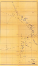
This 1976 map titled "Saudi Arabian Gas Program Location Map" delineates the extensive network of gas fields, pipelines, and infrastructure critical to Saudi Arabia's burgeoning energy sector. Created under the auspices of the Arabian American Oil Company (ARAMCO), it provides a comprehensive overview of the Kingdom's gas operations, including fields, stations, and terminals throughout its eastern region.
In the mid-20th century, Saudi Arabia experienced a transformative economic boom due to the exploration and exportation of oil and natural gas. This period saw ARAMCO at the forefront of developing the nation's vast hydrocarbon resources. The map's representation of various fields such as Khafji, Zuluf, and the prolific Ghawar, alongside infrastructure like the Dammam International Airport and Riyadh Road, encapsulates a nation at a pivotal moment of infrastructural expansion and economic growth.
The map's utility extends beyond its depiction of physical locations; it serves as a historical document reflecting the geopolitical and economic conditions of the 1970s Middle East. It details the extensive network of gas-oil separation plants (GOSPs), inhabited areas, and service stations, demonstrating the scale of Saudi Arabia's ambition and its pivotal role in the global energy market.
Rarity
We find no other examples in general online searches nor in OCLC.
![[Mecca and the Kaaba]](https://storage.googleapis.com/raremaps/img/small/79544.jpg)