


|
||

|

|
|

|
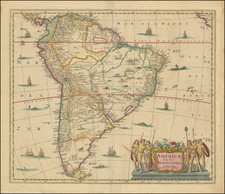
Fine large map of South America, colored by countries, illustrating the continent in the midst of its Century or Revolution.
The map uses an imaginative system of colors an lines to illustrate the prevailing currents in the Atlantic and Pacific, with regional commentary.
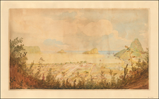
First drawn by Alexander von Humboldt, the image at the bottom left, representing the heights of the mountains and rivers. This image is an intricately detailed engraving depicting a cross-section of the Andean mountain range within the equatorial zone, specifically between 0-2 degrees of southern and northern latitude. It is labeled in French, and part of the title reads "Zone Equatoriale des Andes," indicating that it illustrates the equatorial region of the Andes Mountains. The illustration is likely derived from the explorations of Alexander von Humboldt, Aimé Bonpland, and possibly others such as Pentland, whose names are mentioned in the subtitle as sources.
The cross-section shows various peaks and their respective altitudes, with meticulous attention to the topographical diversity of the region. Prominent peaks such as "Chimborazo" and "Cotopaxi" are clearly labeled, reflecting their significance and the European interest in these geographic landmarks during the period of exploration and scientific study. The image also depicts different vegetation zones, from the densely forested areas at lower altitudes to the barren, snow-capped peaks. The presence of cultivated fields at the lower levels suggests human habitation and agriculture.
This type of illustration would have been used in the 19th century for both scientific and educational purposes, to convey a sense of the region's geography, climate zones, and the natural sciences to a European audience. The detailed engraving style is typical of the period, with a focus on accuracy and the desire to visually communicate the findings of scientific expeditions.
![[ World & Continents ] Typus Orbis Terrarum / Americae Sive Novi Orbis Nova Descriptio / Asiae Nova Descriptio / Africae Tabula Nova / Europae](https://storage.googleapis.com/raremaps/img/small/99250.jpg)


![[ South America ] Carte Encyprotype, de l' Amérique Meridionale . . . 1816 [Wall Map]](https://storage.googleapis.com/raremaps/img/small/69010.jpg)