|
||

|

|
|

|
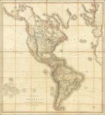
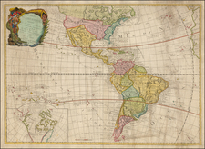
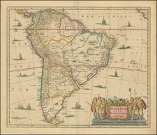
Beautiful engraved and highly detailed four-sheet wall map of South America at the beginning of its Century of Revolution.
The map reflects the extent of European knowledge and explorations into the interior of the continent, which was advanced, but still far from complete. One of the best large format maps of South America from the period.
The 1818 state of the map can be readily differentiated from the 1816 by the inclusion of an engraved "stamp" to the lower-right of the title, which says "Revue & Augmentée par l'Auteur en Avril 1818".
The map is replete with political information, including the following labeled polities:
- Nouveau Royaume de Grenade
- Royaume de Quito
- Territoire des Missions ou Pays des Amazones
- Governement de Caracas
- Guyane Anglaise
- Guyane Hollandaise
- Guyane Francaise
- Guyane Portugaise
- Brasil
- Gouvernement de Buenos-Ayres
- Vice-Royaute de La Playa
- Chile our Chili
- Chiaca ou Patagonie
- Provce. de Chaco
- Paraguay
- Province de Chiquitos
- Province des Moxos
This is the first time we have had this edition of the map; we had the 1816 only once, more than 10 years ago.
Andre Hubert Brué was a French geographer and cartographer. Born in Paris, he served in the French Navy, joining the Baudin expedition to the Pacific (1800-1804). After his sea service, Brué applied his navigation and charting skills to creating finely-crafted maps, which were renowned for their crisp engraving and accuracy. He drew directly on the copper of the plate, creating what he called encyprotypes. He is best known for the Atlas universal de géographie physique, politique, ancienne et moderne.