


|
||

|

|
|

|
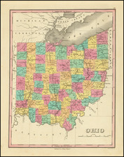
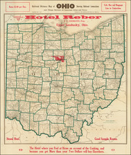
Very nice depiction of the state of Ohio and the various rail lines that connect the state.
This map was created by the Consolidated Map Company for J.F. Goodlove, the proprietor of the Hotel Reber in Upper Sandusky, Ohio. A red pointing finger on the map indicates the area where the hotel was located.
These rail lines are depicted mainly in black save for the electric lines which are shown in a dashed green. The ample amount of tracks running through the state suggests a connected populace able to travel with relative ease between areas of the state. The ample access to rail lines and other means of travel may explain why a hotel would produce a promotional brochure such as this one. The addition of electric tracks is interesting, indicating the rise of electrical technology and power in the United States during the early 1900s. The map labels the company that owns and operates the specific tracks.
The map depicts all the counties of Ohio, outlined in green to show the district boundaries. Inside these counties are many cities or towns, notably Columbus, Springfield, Toledo, and Cincinnati. The map's depiction of towns is usually restricted to those that appear to be along the rail lines, but some exceptions are shown.
Above the neatlines of the chart is some text that lists the the rate to stay a night and various amenities for guests like steam heat or access to bus or cabs once there. The text on the lower portion of the chart appears to be the slogan/motto for the Hotel Reber. This style of map produced by the Consolidated Map Company appears to be popular promotional material for hotels in the region. Several other examples of this map exist, unchanged save for the name of the hotel and the printed slogan or amenities. Here is the Columbus Metropolitan Libraries of a similar map from the same year.
![The Cities of Pittsburgh and Allegheny with Parts of Adjacent Boroughs [with] The City of Cincinnati Ohio.](https://storage.googleapis.com/raremaps/img/small/82569.jpg)