|
||

|

|
|

|
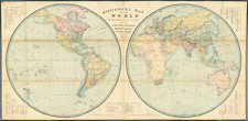
Detailed and elegant map of the world, published in Paris in 1866.
Produced by Eugene Andriveau-Goujon in Paris, this colorful map shows the territorial, colonial, and national boundaries of the world. Most strikingly, many islands and pieces of Africa, Asia, and the Americas are underlined/colored the same color as European countries. While some of this may be coincidence, islands like Hong Kong, New Zealand, and the Falklands are depicted with the same color as England. Likewise, France is depicted with sizable holdings in Algeria and Guinea.
Maritime locations are quite plentiful and many include a date when they were discovered. Increased islands illustrate the rise in naval cartography and navigation during the mid to late nineteenth century. Increased detail throughout the world as well.