|
||

|

|
|

|
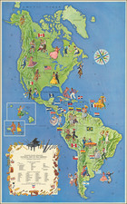
This map drafted by Emmanuel, Comte de Las Cases and engraved by Alexandre Moisy around 1835, presents a detailed representation of the Western Hemisphere. Its extensive coverage spans from the Arctic expanses of the north to the southern reaches of Tierra del Fuego, incorporating the Caribbean Sea and segments of the adjacent oceans. The map is notable for its delineation of the territories and populations of the countries within the Americas, alongside significant historical routes of exploration and conquest.
The detailed annotations and routes, such as those of Columbus's voyages, Cortez's march through Mexico, Pizarro's campaign in Peru, and Lewis and Clark's expedition, provide a narrative of exploration and territorial acquisition.
Moreover, the surrounding text and tables offer a wealth of information in French. These elements provide insights into the population and territorial size of the countries depicted, as well as contextual information about key historical events, including the American Revolutionary War.
Engraved by Moisy with lettering by Bénard and published by Paul Renouard, it stands as a scholarly record of the era's cartographic and geopolitical understanding, preserved through the meticulous process of mapmaking.
![America noviter delineata Auct. Judoco Hondio [Extremely rare 3 panel carte a figures state]](https://storage.googleapis.com/raremaps/img/small/66116.jpg)