|
||

|

|
|

|
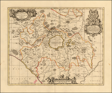
Nice old color example of Blaeu's map of the north part Calabria.
This ornate map, Calabria Citra olim Magna Graecia by Willem Blaeu in Amsterdam, captures the historical and geopolitical essence of Calabria Citra as it was in the first half of the 17th century. This region, resonant with the echoes of its Greek colonial past, was intricately tied to the vast tapestry of Mediterranean geopolitics.
In the 17th century, Calabria Citra was under Spanish rule, as part of the Kingdom of Naples, during the apex of Spanish power. The geopolitical climate of the period was dominated by the rivalries between the European powers, with Spain, France, the Ottoman Empire, and the various Italian states vying for control and influence over the Mediterranean. Calabria, with its strategic coastal towns and ports, was a focal point for military and naval activities, and it played a significant role in the maritime trade networks.
The map captures the region's intricate network of settlements, its rugged terrain, and the vital courses of waterways like the Lao and Crati rivers, which are prominently displayed. Blaeu's map meticulously charts the geopolitical divisions of the Calabrian territory, reflecting the administrative organization put in place by the Spanish viceroys.
Includes and elaborate title cartouche.
Willem Janszoon Blaeu (1571-1638) was a prominent Dutch geographer and publisher. Born the son of a herring merchant, Blaeu chose not fish but mathematics and astronomy for his focus. He studied with the famous Danish astronomer Tycho Brahe, with whom he honed his instrument and globe making skills. Blaeu set up shop in Amsterdam, where he sold instruments and globes, published maps, and edited the works of intellectuals like Descartes and Hugo Grotius. In 1635, he released his atlas, Theatrum Orbis Terrarum, sive, Atlas novus.
Willem died in 1638. He had two sons, Cornelis (1610-1648) and Joan (1596-1673). Joan trained as a lawyer, but joined his father’s business rather than practice. After his father’s death, the brothers took over their father’s shop and Joan took on his work as hydrographer to the Dutch East India Company. Later in life, Joan would modify and greatly expand his father’s Atlas novus, eventually releasing his masterpiece, the Atlas maior, between 1662 and 1672.
![Paese di Roma [Country of Rome]](https://storage.googleapis.com/raremaps/img/small/75612.jpg)