


|
||

|

|
|

|
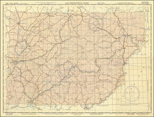
Scarce map of the Franz Josef Land, illustratiing the Julius Payer Expedition of 1873 and 1874.
Franz Josef Land, is an archipelago located in the Arctic Ocean north of Novaya Zemlya and east of Svalbard, The archipelago was possibly first discovered by the Norwegian sealers Nils Fredrik Rønnbeck and Aidijärvi aboard the schooner Spidsbergen in 1865 who, according to scarce reports, sailed eastward from Svalbard until they reached a new land, denoted Nordøst-Spitsbergen (Spitsbergen was the contemporary name of Svalbard). It is not known if they went ashore, and the new islands were soon forgotten.
The map is drawn from observations made during the Austro-Hungarian North Pole expedition of 1872-74, taken from surveys conducted by Julius Payer, charts the complex archipelago of Franz Josef Land with a detail unprecedented at the time of its creation.
Franz Josef Land, an Arctic archipelago only formally discovered in 1873 during the Austro-Hungarian North Pole expedition, is delineated with careful attention to the topography and hydrography, revealing the intricate interplay of land and sea in one of the planet's most extreme environments. The detailing of the glaciated landscape, with its myriad of islands, channels, and ice floes, provides invaluable insights into the geography of this remote region.
The key, with explanations in German, clarifies the various markings on the map. It details the depths in meters, the tracks of the ship "Tegetthoff" until the 1st of November, 1873, and the routes taken by Payer's sledge expeditions from March to May of 1874. These annotations offer a historical narrative, encapsulating the story of exploration and the arduous journey of the explorers as they navigated through the open waters, perennial ice, and icebergs.
August Heinrich Petermann (1822-1878) is a renowned German cartographer of the nineteenth century. Petermann studied cartography at the Geographical Art-School in Potsdam before traveling to Edinburgh to work with Dr. A. Keith Johnston on an English edition of Berghaus’ Physical Atlas. Two years later he moved to London, where he made maps and advised exploratory expeditions as they set off to explore the interior of Africa and the Arctic.
In 1854, Petermann returned to Germany to be Director of the Geographical Institute of Justus Perthes in Gotha. There, he was the editor of the Geographische Mittheilungen and Stieler’s Handatlas. The Royal Geographical Society of London awarded him their Gold Medal in 1860. He continued his interest in exploration in Germany, fundraising for the German Exploring Expeditions of 1868 and 1869-70, which sought an open Arctic sea. Tragically, he committed suicide in 1878.
![Il Disegno Della Terza Parte Dell' Asia [Gastaldi's Wall Map of SE Asia with extra panels!]](https://storage.googleapis.com/raremaps/img/small/30554hbp.jpg)
![(Anti-Nato Propaganda) Военные Блоки-Оплот Милитаризма [Military Blocs-Strongholds of Imperialism]](https://storage.googleapis.com/raremaps/img/small/94274.jpg)
![[ Russia, Poland, Ukraine, Belarus ] Kriegsstrassen Karte Eines Theiles Von Russland und der Angraenzenden Laender. Nach der unter der Leitung des Russ. kaiserlichen Generalstabes vom General Major Schubert im Masstabe von 1/1680000 im Jahre 1829 hrsg. Karte - auf das Mass von 1/1400000 vergrössert, von dem k.k. ofterr Generalquartierm eisterstabe Herausgegen im Jahre 1837.](https://storage.googleapis.com/raremaps/img/small/100484.jpg)
![[ St. Peterburg ] Plan de St. Petersbourg et de ses environs relatif au Memoire, concernant les moyens de mettre cette ville a l'agbri des inondations et d'etablir deux grands ports, dessine d'apres des cartes exactes, par le chevalier de Wiebeking, conseiller prive de S.M. le Roy de Baviere, etc. (With separately published Legende du Plan De St.-Petersbourg . . . )](https://storage.googleapis.com/raremaps/img/small/64539.jpg)