|
||

|

|
|

|
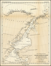
Petermann's map delineates the ambitious American North Polar Expedition led by Captain Charles Francis Hall in 1871-72, as documented by German geographer and publisher Augustus Petermann. The map provides one of the first contemporary accounts of Hall's Arctic exploration during a period of intrepid voyages and geographical enlightenment.
The map offers a comprehensive view of the Arctic's labyrinthine waterways, coastlines, and the ethereal polar landscape navigated by Hall. It employs a scale of 1:1,900,000, allowing for detailed observation of Hall’s routes by ship, boat, and sledge. Petermann supplements the map with the inclusion of comparative trails from previous expeditions, each delineated by distinct lines and symbols, providing a layered historical perspective on the exploration of the northernmost reaches of the Earth.
The American North Polar Expedition under Hall was a significant endeavor aimed at locating the Northwest Passage and reaching the North Pole. Though ultimately tragic due to Hall's untimely death under mysterious circumstances, the expedition added valuable knowledge to the cartography of the Arctic regions.
Earlier expeditions represented on the map include those by Elisha Kent Kane in 1853, Isaac Israel Hayes in 1860-61, and the second Grinnell Expedition led by Edwin De Haven in 1850-54. Kane’s foray was pivotal for its extensive scientific observations and northern reach, while Hayes is credited with charting previously unknown regions, claiming to have reached a “farthest north” point. The second Grinnell Expedition, though not reaching its intended goal, succeeded in charting new islands and channels.
August Heinrich Petermann (1822-1878) is a renowned German cartographer of the nineteenth century. Petermann studied cartography at the Geographical Art-School in Potsdam before traveling to Edinburgh to work with Dr. A. Keith Johnston on an English edition of Berghaus’ Physical Atlas. Two years later he moved to London, where he made maps and advised exploratory expeditions as they set off to explore the interior of Africa and the Arctic.
In 1854, Petermann returned to Germany to be Director of the Geographical Institute of Justus Perthes in Gotha. There, he was the editor of the Geographische Mittheilungen and Stieler’s Handatlas. The Royal Geographical Society of London awarded him their Gold Medal in 1860. He continued his interest in exploration in Germany, fundraising for the German Exploring Expeditions of 1868 and 1869-70, which sought an open Arctic sea. Tragically, he committed suicide in 1878.
![[ Pacific Northwest - Northwest Passage ] Limes Occidentis Quivira et Anian. 1597](https://storage.googleapis.com/raremaps/img/small/71207.jpg)