


|
||

|

|
|

|
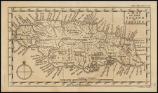
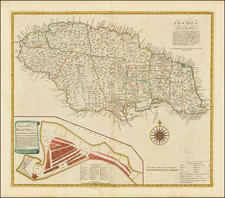
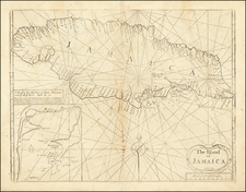
Striking example of Mount & Page's map of hte island of Jamaica.
The map shows the topography and colonial divisions of Jamaica in the 18th century with remarkable precision. The delineation of parishes, cities, ports, and plantations reflects the island's economic and strategic significance in the Caribbean, particularly within the context of the British Empire's mercantile system.
By 1770, Jamaica was divided into several parishes, each functioning as a unit of local government and economic activity. Notable among these were Saint Andrew, Saint Catherine, and Saint James, regions that were densely populated and held economic prominence due to their productive plantations and ports. In Saint James parish, the city of Montego Bay was emerging as a significant port for the export of sugar and rum. Similarly, in the parish of Saint Catherine, the town of Spanish Town (then St. Jago de la Vega) served as the bustling capital of the island until the end of the 18th century.
The island's southern coast boasted major ports such as Kingston and Port Royal. Kingston, in particular, was a vital commercial hub, with its harbor accommodating ships from across the Atlantic, bearing goods and enslaved Africans. Port Royal, once known as "the richest and wickedest city in the world," had declined after the 1692 earthquake destroyed the city, although it remained an important poirt town.
Plantations dotted the Jamaican landscape, shaping much of the island's interior and coastal regions. A number of anchorages are shown, along with coastal mountains.
![[War of Jenkins Ear in Florida and West Indies] [Harbors, Towns & Fortresses of North America, St. Augustine, Providence (Grand Bahama Island), Porto Antonio (Jamaica), Havana, Santiago (Cuba), Kingston, and Antiqua)]](https://storage.googleapis.com/raremaps/img/small/75642.jpg)