


|
||

|

|
|

|
Stock# 91033
Description
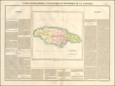
Finely crafted map of Jamaica, published in London by Carrington Bowles.
The map provides a remarkably detailed, locating towns, churches, forts, sugar works, gentlemen's seats, taverns, crawls, roads, parishes, barracks and other details. In addition to sugar works, the map locates "Pens Ginger Coffee & Indigo Settlements." Along the coastline there are a few soundings, safe anchorages and navigational hazards noted.
A large inset provides a plan of Port Royal that shows the infamous pirate stronghold both before and after the earthquake that destroyed much of the town in 1692.
Reference
Kapp #69

![Jamaiqua [and] Cuba](https://storage.googleapis.com/raremaps/img/small/105780.jpg)
![Island of Cuba (Spanish) and Jamaica (British) [also South Florida, Bahamas and Cayman Islands]](https://storage.googleapis.com/raremaps/img/small/98323.jpg)
