|
||

|

|
|

|
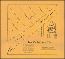
1920s Real Estate Map of West Hollywood
This 1920s map, likely an advertisement by Taft Realty Company, showcases two blocks of homes in West Hollywood, including notable streets like Hollywood Boulevard and Hillside Avenue. Produced during Los Angeles' rapid expansion due to the rising entertainment industry, the map reflects the region's growth in wealth and population. It displays lot measurements and layouts, with some properties marked potentially indicating prices. The map covers a specific section featuring Fairfax Avenue, Ogden Drive, and Hillside Avenue, leaving out the rest of the area.
Manuscript Annotations
This map features several annotations, presumably made to indicate the availability of certain properties. Many of the lots in question are crossed out in grey, implying that they are already sold or occupied. Several properties have additional lines and numbers written in red pen. These numbers likely indicate the availability of these lots and the price associated with them. The prices are not unexpected for new property in a desirable area like West Hollywood during the 1920s.
![[ Norma Triangle / West Hollywood / Sunset Strip / Santa Monica Blvd ] Map of West Knoll Los Angeles County, California](https://storage.googleapis.com/raremaps/img/small/97769.jpg)