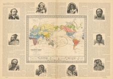
|
||

|

|
|

|
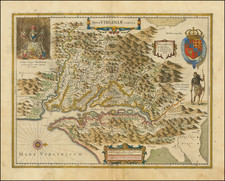
Fine view on the Georgia Coastline, based upon original watercolor paintings by Jacques Le Moynes de Morgues, an official French artist, who accompanied two important French Expeditions to North America in the 1560s.
The images show the French explorations on the Georgia Coastline, which were first published in 1591, by Theodore de Bry. Taken from the publication of the reports of Jean Ribault (1562) and Rene Goulaine de Laudonniere (1564) expeditions, entitled Brevis narratio eorum quae in Florida Americœ provincia Gallis acciderunt . . .
The text translates as follows:
After they returned to their ships and lifted the anchors, they sailed further along the coast until they happened upon a pleasant river. The Prefect wanted to observe it along with its local ruler and indigenous people. He gave the river the name Sequana because it resembled the river Sequana in Gaul; it is about 14 leagues away from the River May. Then they returned to their ships and sailed further to the north. But not long after they had departed, they found another sufficiently elegant river, for the purpose of observing which they deployed two boats. In it they found an island, whose king was no less friendly than those encountered before. They gave this river the name Axone; it is about six miles away from Sequana.
On the first French voyage to the region which would be described as French Florida, the crew, led by Captain Jean Ribaut, landed at a promontory which later become Fort Augustine. Following the coast north from there, Ribault's expedition discovered a broad river, which they called May. After exploring the region, they proceeded further and sailed farther up the coast until they reached another river which Captain Ribaut deemed worthy of exploration. He called this river the Sequana River, the ancient Latin name for the Seine River. After a brief investigation, the expedition continued a short distance north, before encountering another large river, which they named the Axone River (Latin name for the Somme River in France). This river was explored in two small boats.
Ribault named this river the Somme or Axona, which is about six miles from the Seine. The river marked on the engraving 'F. Axona, Iricana' is evidently the Somme, but has the suffix Iracana, after the Indians on this river. Today, it is known as St. Andrews Sound, Georgia, at the mouth of the Satilla River and Jekyll Island. The fish-pens, shown in the river estuary, are 'reed enclosures made in the form of a labyrinth' by the Indians, and from which the fish found it almost impossible to escape.
Theodor de Bry (1528-1598) was a prominent Flemish engraver and publisher best known for his engravings of the New World. Born in Liege, de Bry hailed from the portion of Flanders then controlled by Spain. The de Brys were a family of jewelers and engravers, and young Theodor was trained in those artisanal trades.
As a Lutheran, however, his life and livelihood were threatened when the Spanish Inquisition cracked down on non-Catholics. De Bry was banished and his goods seized in 1570. He fled to Strasbourg, where he studied under the Huguenot engraver Etienne Delaune. He also traveled to Antwerp, London, and Frankfurt, where he settled with his family.
In 1590, de Bry began to publish his Les Grands Voyages, which would eventually stretch to thirty volumes released by de Bry and his two sons. The volumes contained not only important engraved images of the New World, the first many had seen of the geographic novelties, but also several important maps. He also published a collection focused on India Orientalis. Les Grands Voyages was published in German, Latin, French, and English, extending de Bry’s fame and his view of the New World.
![(Mató-Tópe) Indianer Geschmuckt Mit Den Zeichen Seiner Kriegsthaten, Indien décoré des emblèmes de ses faits d'armes [Mandan warrior chief Mató-Tópe, aka Ma-to-toh-pe or Four Bears]](https://storage.googleapis.com/raremaps/img/small/81193.jpg)
![[ Atlanta ] Mr. Gilmore's Official City Map of Greater Atlanta and Suburbs](https://storage.googleapis.com/raremaps/img/small/98689.jpg)