


|
||

|

|
|

|
African Exploration by David Livingstone's Father-in-Law.
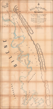
Map to Illustrate Route from Colesberg to Steinkopf, authored by Robert Moffat (called Moffatt on the map) in 1858 and published in the Journal of the Royal Geographical Society by J. Murray, with engraving by John Arrowsmith, offers a detailed representation of the diverse landscape of South Africa, particularly along the banks of the Orange River towards the Bechuana Country. This notable map, produced at a time when the interior of the African continent was still relatively unknown to European audiences, elucidates Moffatt's extensive travels and his deep familiarity with the region.
The mid-1800s saw a surge of missionary and exploratory endeavors into the heart of the continent, seeking to shed light on its terrains, peoples, and potential. Moffatt, with his prolonged engagement with the Batswana people and his contributions to the spread of Christianity in Africa, was uniquely positioned to craft such a map. His personal journey, marked by resilience in the face of adversity and a commitment to his mission, finds its reflection in the map's detailed routes and annotations.
The distinction of this map, apart from its cartographic accuracy, lies in its embodiment of the juxtaposition between European exploration and the African landscape. The delineation of the route, stretching from Colesberg in the east to Steinkopf in the west and along the Orange River, captures not only the geographical intricacies but also the broader narrative of European engagement with Africa during the 19th century. In drawing attention to regions such as the Bechuana Country, Moffatt's map serves as a testament to his deep-rooted connections with South Africa, allowing readers a glimpse into a land that was at the forefront of exploration and missionary activity.
Robert Moffat
Robert Moffat (1795-1883) was a pioneering Scottish Congregationalist missionary known for his dedicated service in Africa and his commitment to spreading Christianity among the Batswana people. Born in Ormiston, East Lothian, he initially pursued a career as a gardener in Cheshire. However, following his Methodist convictions, he joined the London Missionary Society in 1816 and embarked on a mission to South Africa. Once there, Moffat faced numerous adversities, often dealing with extreme scarcity of food and water. He is most renowned for translating the Bible and "The Pilgrim's Progress" into Setswana, though contemporary critiques highlight colonial biases in his work. Moffat's legacy is cemented not only in his missionary accomplishments but also through his daughter Mary, who married the famed explorer David Livingstone. By the end of his life, Moffat had earned recognition from the Royal Geographical Society and Edinburgh University and had even been presented to Queen Victoria. Today, he is commemorated through various means, including a memorial run in High Legh and the preservation of his printing press in Kuruman.
The Arrowsmiths were a cartographic dynasty which operated from the late-eighteenth century to the mid-nineteenth. The family business was founded by Aaron Arrowsmith (1750-1823), who was renowned for carefully prepared and meticulously updated maps, globes, and charts. He created many maps that covered multiple sheets and which were massive in total size. His spare yet exacting style was recognized around the world and mapmakers from other countries, especially the young country of the United States, sought his maps and charts as exemplars for their own work.
Aaron Arrowsmith was born in County Durham in 1750. He came to London for work around 1770, where he found employment as a surveyor for the city’s mapmakers. By 1790, he had set up his own shop which specialized in general charts. Arrowsmith had five premises in his career, most of which were located on or near Soho Square, a neighborhood the led him to rub shoulders with the likes of Joseph Banks, the naturalist, and Matthew Flinders, the hydrographer.
Through his business ties and employment at the Hydrographic Office, Arrowsmith made other important relationships with Alexander Dalrymple, the Hudson’s Bay Company, and others entities. In 1810 he became Hydrographer to the Prince of Wales and, in 1820, Hydrographer to the King.
Aaron Arrowsmith died in 1823, whereby the business and title of Hydrographer to the King passed to his sons, Aaron and Samuel, and, later, his nephew, John. Aaron Jr. (1802-1854) was a founder member of the Royal Geographical Society (RGS) and left the family business in 1832; instead, he enrolled at Oxford to study to become a minister. Samuel (1805-1839) joined Aaron as a partner in the business and they traded together until Aaron left for the ministry. Samuel died at age 34 in 1839; his brother presided over his funeral. The remaining stock and copper plates were bought at auction by John Arrowsmith, their cousin.
John (1790-1873) operated his own independent business after his uncle, Aaron Arrowsmith Sr., died. After 1839, John moved into the Soho premises of his uncle and cousins. John enjoyed considerable recognition in the geography and exploration community. Like Aaron Jr., John was a founder member of the RGS and would serve as its unofficial cartographer for 43 years. Several geographical features in Australia and Canada are named after him. He carried the title Hydrographer to Queen Victoria. He died in 1873 and the majority of his stock was eventually bought by Edward Stanford, who co-founded Stanford’s map shop, which is still open in Covent Garden, London today.
![Egypt and Barca [with] Abissina and Nubia [with] Congo. Angola. Cafres. Monoemugi. Monomotapa. Zanguebar & Madagascar](https://storage.googleapis.com/raremaps/img/small/78890.jpg)
![[False Bay] In de Baay Falso](https://storage.googleapis.com/raremaps/img/small/61861.jpg)