|
||

|

|
|

|
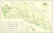
Bilene, Mozambique -- Rio Limpopo From Chibuto to Military Post of Languene
Rare separately published map of a portion of the Limpopo River, from the Mount Chibuto Region to the Military Post of Languene, just north of Xai-Xai District.
The map was prepared in conjunction with the war being fought by local tribes against the Portuguese in 1895.
The map focuses on the rich agricultural lands drained by the Lower Limpopo, just north of its confluence with the sea. The key identifies:
- Sand dunes with grass
- Swamp land
- Populations of huts
The title translates as follows:
Hydrographical sketch of the Limpopo River between the Patos Island and the Gongunhana Range, extending from the Changâne River to Monte Chibuto: made by the 1st Lieutenant of the Navy Alvaro Andréa commander of the Lancha C.ª Capêllo during the campaign operations from September to December, 1895.
![[Simon's Town / False Bay, South Africa] Seamons Bay in the Bay of False](https://storage.googleapis.com/raremaps/img/small/87276.jpg)
![[South African Republic, Orange Free State, Natal, Basutoland, etc.] The Absent-Minded Beggar](https://storage.googleapis.com/raremaps/img/small/78441.jpg)