|
||

|

|
|

|
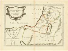
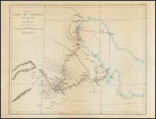
This map, reproduced by the 512th A. Field Survey Company, R.E., in February 1942 and subsequently revised in 1944 and 1945, delineates the geography and political boundaries of the northern Persian Gulf region, centering on Bushire, in present-day Iran. It is a detailed representation of the area's topography and settlements, including southeastern Iraq, southwestern Persia, portions of Kuwait, and the Saudi Arabian coast.
During the mid-20th century, particularly in the 1940s, the Middle East was a region of significant geopolitical interest and change, marked by the discovery of oil, shifting colonial powers, and the early stages of state formation in the Arabian Peninsula. The map reflects the era's intense surveying efforts, aimed at understanding and navigating the strategic, resource-rich area. Its compilation reflects the technological and political advancements of wartime cartography and the crucial role of accurate mapping in military and geopolitical strategies.
The technical precision of this map is evident in its detailed notation of topographical features such as mountain ranges, valleys, and water bodies, along with human-made structures including oil wells, railways, and telegraph lines. It serves as an important historical document, revealing the landscape and infrastructural developments of the time. The map also includes a glossary of Iranian and Arabic geographical terms, indicating a depth of local engagement and understanding.
Lastly, the map's notation that the boundary between Iran and Iraq "should not be considered as final" underscores the ongoing territorial negotiations and the fluid nature of political boundaries in the region.