


|
||

|

|
|

|
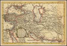
Persia, an exquisite 1679 map crafted by the renowned English cartographer John Seller, presents a comprehensive view of a region spanning present-day Iran and Afghanistan, extending to the "Mare Arabicum et Indicum" (the Arabian and Indian Seas). This piece, featured in the esteemed Atlas Minimus, exemplifies the precision and elegance of Seller's cartographic style.
Seller's work was pivotal in the 17th century, a time of significant exploration and discovery. The Persia map encapsulates this era, portraying the geographical understanding of this wide-ranging territory. With its portrayal of the Arabian and Indian Seas, the map incorporates significant maritime routes, highlighting the interconnectedness of these regions through trade and exploration.
Adjacent to the map, an engraved table meticulously lists provinces and cities of the region. This inclusion provides an insightful layer of sociopolitical context to the geographical representation, highlighting the administrative divisions and urban centers of the period. It's a testament to Seller's meticulousness and commitment to providing comprehensive information to the map's users.
John Seller's Persia stands as an important historical record, offering a fascinating glimpse into the geography and sociopolitical structure of the region during the late 17th century. Its detailed depiction of territories and associated table of names reflect the era's cartographic practices and understanding, making this map a significant piece in the history of cartography.
John Seller was one of the most notable map and instrument makers in England in the late-seventeenth century. He was especially known for the sea charts, many of which featured in his influential English Pilot and Atlas Maritimus. Seller was born in London in 1632. His father was a cordwainer and John was apprenticed to Edward Lowe, of the Merchant Taylors’ Company. He was made free of that company in 1654. Later, he also was made a brother of the Clockmakers’ Company, which housed several instrument makers. He started business as a compass maker but expanded his offering to include navigational instruments and charts.
Seller’s career was halted temporarily, and fantastically, when he was tried for high treason in 1662. He was accused of involvement in a plot led by Thomas Tonge. While Seller likely only unwisely repeated rumors, he was convicted. The other conspirators, who did admit some degree of guilt, were executed, but Seller maintained his innocence and, via insistent petitions, he eventually secured his release from Newgate Prison.
This episode did not seem to slow Seller’s rise too much, however. Seller was granted a royal license to publish English-language maritime atlases. This gave him a near-monopoly and led to his being named hydrographer to the King in 1671. Although the point of the project was to produce English charts of Dutch dominance and bias, Seller ended up using many Dutch plates as his base material. The first volume of The English Pilot was published in 1671, followed by more volumes as well as The Coating Pilot (1672) and the Atlas Maritimus (1675). Seller was commercially successful, but some of his projects required further support. The English Pilot was eventually taken over by John Thornton and William Fisher, for example, and his proposed English atlas only produced maps of six counties.
Seller’s sons, John and Jeremiah, followed in their father’s profession. Seller also apprenticed several promising young men, including Charles Price, with whom his sons partnered. Through Price, Seller can be seen as the founding figure of an important group of London mapmakers that included Price, John Senex, Emanuel Bowen, Thomas Kitchin, and Thomas Jefferys.
![[Kashan] Kachan کاشان](https://storage.googleapis.com/raremaps/img/small/87841.jpg)
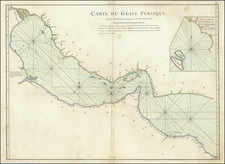
![[ Arabian Gulf / Persian Gulf ] Golfe Persique Dresse en 1758 et publie en 76 . . .](https://storage.googleapis.com/raremaps/img/small/100245.jpg)