|
||

|

|
|

|
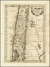
Scarce example of the Frankfurt edition of Sanson's early regional map of the southern tip of South America, from P. de las Baixas and Port Desire in the east and the southern portion of Chile in the west, showing Magellanica in remarkable detail, including Staten land, Destroit de Browers, Cape Horn, Diego Ramirez, and many other points, capes, islands, straits, etc.
The map first appeared in Sanson's L'Amerique en Plusieurs Cartes Nouvelles… the third atlas to focus solely upon America in 1657.
This example is from Johann Zurner's Die Gantz Erd-Kugel, published in Frankfurt in 1679. The Zurner edition is the only edition to include the title in Spanish.
Nicholas Sanson (1600-1667) is considered the father of French cartography in its golden age from the mid-seventeenth century to the mid-eighteenth. Over the course of his career he produced over 300 maps; they are known for their clean style and extensive research. Sanson was largely responsible for beginning the shift of cartographic production and excellence from Amsterdam to Paris in the later-seventeenth century.
Sanson was born in Abbeville in Picardy. He made his first map at age twenty, a wall map of ancient Gaul. Upon moving to Paris, he gained the attention of Cardinal Richelieu, who made an introduction of Sanson to King Louis XIII. This led to Sanson's tutoring of the king and the granting of the title ingenieur-geographe du roi.
His success can be chalked up to his geographic and research skills, but also to his partnership with Pierre Mariette. Early in his career, Sanson worked primarily with the publisher Melchior Tavernier. Mariette purchased Tavernier’s business in 1644. Sanson worked with Mariette until 1657, when the latter died. Mariette’s son, also Pierre, helped to publish the Cartes générales de toutes les parties du monde (1658), Sanson' atlas and the first French world atlas.
Adam Friedrich Zürner (15 August 1679 – 18 December 1742) was a German Protestant priest, cartographer and the head of construction of the Kursächsische Postmeilensäulen in Saxony.
Zurner's first project of note was a map of Saxony, for which he was retained by August III, King of Poland, in 1711.
Zurner was appointed Geographer of Poland and the Electorate of Saxony, a position in which he served until 1732. In this time period, he reportedly traveled nearly 18,000 miles and created over 900 maps.
In 1721, he was tasked with establishing a postal road system in Saxony and marking the distances with stone posts.
His work resulted in the Atlas Augusteus Sauronicus (40 maps plus key sheet), which remained incomplete until after Zurner's death, but was ultimately sold to Pieter Schenk in Amsterdam in about 1745. Schenk's completed work (49 maps, published in Amsterdam and Leipzig) was issued without reference to Zurner's name, under the title Atlas Saxonicus.
Despite his prolific work product, none of Zurner's original manuscript maps seem to survive.