


|
||

|

|
|

|
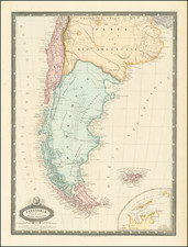
Antique Map of the Rio de La Plata Basin
Early Dutch edition of this detailed early map of the Rio de la Plata Region, showing Buenos Aires, the source of the Rio de la Plata and Paraguay Rivers and extending west to Chile and Peru.
Many major cities appear, as do rivers, lakes, mountains, islands and other details. One of the earliest obtainable regional maps of this area.
The map first appeared in Sanson's L'Amerique en Plusieurs Cartes Nouvelles… the third atlas to focus solely upon America.
Originally published by Sanson, the map was re-issued by Zurner in 1679 in Frankfurt and by Ribbius in 1683 in Utrecht.
Nicholas Sanson (1600-1667) is considered the father of French cartography in its golden age from the mid-seventeenth century to the mid-eighteenth. Over the course of his career he produced over 300 maps; they are known for their clean style and extensive research. Sanson was largely responsible for beginning the shift of cartographic production and excellence from Amsterdam to Paris in the later-seventeenth century.
Sanson was born in Abbeville in Picardy. He made his first map at age twenty, a wall map of ancient Gaul. Upon moving to Paris, he gained the attention of Cardinal Richelieu, who made an introduction of Sanson to King Louis XIII. This led to Sanson's tutoring of the king and the granting of the title ingenieur-geographe du roi.
His success can be chalked up to his geographic and research skills, but also to his partnership with Pierre Mariette. Early in his career, Sanson worked primarily with the publisher Melchior Tavernier. Mariette purchased Tavernier’s business in 1644. Sanson worked with Mariette until 1657, when the latter died. Mariette’s son, also Pierre, helped to publish the Cartes générales de toutes les parties du monde (1658), Sanson' atlas and the first French world atlas.
Adam Friedrich Zürner (15 August 1679 – 18 December 1742) was a German Protestant priest, cartographer and the head of construction of the Kursächsische Postmeilensäulen in Saxony.
Zurner's first project of note was a map of Saxony, for which he was retained by August III, King of Poland, in 1711.
Zurner was appointed Geographer of Poland and the Electorate of Saxony, a position in which he served until 1732. In this time period, he reportedly traveled nearly 18,000 miles and created over 900 maps.
In 1721, he was tasked with establishing a postal road system in Saxony and marking the distances with stone posts.
His work resulted in the Atlas Augusteus Sauronicus (40 maps plus key sheet), which remained incomplete until after Zurner's death, but was ultimately sold to Pieter Schenk in Amsterdam in about 1745. Schenk's completed work (49 maps, published in Amsterdam and Leipzig) was issued without reference to Zurner's name, under the title Atlas Saxonicus.
Despite his prolific work product, none of Zurner's original manuscript maps seem to survive.
![[ Peru and Upper Peru ] Carte Du Perou et Du Haut Perou…1829](https://storage.googleapis.com/raremaps/img/small/98834.jpg)

![Suite Du Bresil . . . [2 maps]](https://storage.googleapis.com/raremaps/img/small/103662.jpg)
![[ Rio de Janeiro ] Planta Informativa Do Centro Da Cidade Do Rio De Janeiro. Especialmente Organisada Para o Guia Briguiet Pelo Professor Arthur Duarte Ribeiro . . . 1932](https://storage.googleapis.com/raremaps/img/small/66693.jpg)