|
||

|

|
|

|
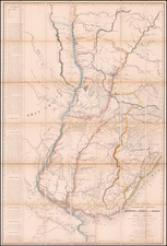
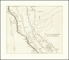
Peru and Upper Peru After the Gran Colombia - Peru War
Striking map of Peru, Bolivia and Ecuador, duirng this fascinating period at the conclusion of Spanish colonial rule.
The map shows towns, roads, rivers, lakes, mountains, islands, bays, points, etc.
The map shows Peru following its independence at the time of the Gran Colombia Peru War.
Beginning in the early 19th Century, Lapie was one of the leading French mapmakers, at a time when much of the great exploration and travel literature was being published in French. Lapie was often the engraver of maps which were included in these books. As a result, he often incorporated the most recent information and discoveries in his maps, often appearing prior to the official report from which the information derived. His maps are now prized for their detail, accuracy and attractive engraving style.
Peruvian Independence
Between 1800 and 1830, Peru's geopolitical landscape underwent significant transformations, marked by the collapse of Spanish colonial rule and the struggle for independence. As the 19th century commenced, Peru was the seat of Spanish power in South America, with Lima hosting the Viceroyalty of Peru, a remnant of the vast and powerful Spanish Empire. This era was characterized by the Bourbon Reforms, which aimed to revitalize the empire and improve its administrative and economic efficiency.
The seeds of independence were sown by the libertarian ideas emanating from the Enlightenment, further spurred by the American and French Revolutions. The invasion of Spain by Napoleonic forces in 1808 and the subsequent abdication of the Spanish King Ferdinand VII in 1808 created a power vacuum that ignited the struggle for independence across the Spanish colonies.
José de San Martín and Simón Bolívar are the two paramount figures in the liberation of Peru. San Martín, leading the southern liberation force, declared Peru's independence on July 28, 1821, after capturing Lima. However, it wasn’t until the decisive Battle of Ayacucho on December 9, 1824, where Antonio José de Sucre, a trusted lieutenant of Bolívar, ensured the independence from Spanish rule with a definitive victory.
Following independence, Peru faced a period of instability and governance challenges. The country was initially a republic with a constitution enacted in 1823, but the realities of governance proved more complex. A series of military coups and uprisings marred the political landscape, leading to frequent changes in leadership and governance structures. Boundaries were also in flux, with disputes over territories with neighboring countries, leading to shifting geopolitical contours.
Upper Peru refers to the territory that is now the modern nation of Bolivia. It was the southeastern part of the Viceroyalty of Peru during the Spanish colonial period. This region was rich in minerals and played a crucial role in the economy of the Spanish Empire due to its silver mines, especially the famed Cerro Rico de Potosí. Upper Peru became a central battleground due to its economic importance and its strategic location between the Viceroyalty of the Río de la Plata and the Viceroyalty of Peru, both of which sought to exert influence over the region.
After the wars of independence and the subsequent retreat of Spanish forces following the Battle of Ayacucho in 1824, Upper Peru was left in a state of uncertainty. It was initially intended to be part of the territories liberated by Simón Bolívar and José de San Martín, which were to become a part of the newly independent countries of Peru or the United Provinces of the Río de la Plata (later Argentina). However, the aspirations of the local population, along with political maneuverings, led to the creation of a separate entity. On August 6, 1825, after a deliberative assembly, Upper Peru proclaimed its independence from Spanish rule and named itself the Republic of Bolívar in honor of Simón Bolívar. The name was soon changed to Bolivia, and the region's history diverged from Peru's, evolving into a distinct national entity with its own unique challenges and developments.
The Gran Colombia-Peru War of 1828-1829 further complicated the regional dynamics, involving territorial disputes over the region that would later become Ecuador. This conflict ended with the Treaty of Guayaquil in 1829, which was meant to establish boundaries between the two nations, although ambiguities in the treaty would lead to further disputes.
![[ Manuscript Map of Province of Quito ] Carta de la Provincia de Quito i de sus adyacentes, obra postuma de Don Pedro Maldonado . . . Paris MDCCL](https://storage.googleapis.com/raremaps/img/small/98908op.jpg)