|
||

|

|
|

|
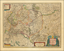
A New Map of Swisserland Divided Into Its Cantons and Dependencies, Including The Grisons &c. &c. . . . 1799, is an intricate regional map of Switzerland by John Cary of London. With precise representations of towns, roads, rivers, mountains, lakes, and castles, the map provides an important portrait of Switzerland at the end of the 18th century.
At the time of the map's creation, Europe was in the throes of the French Revolution, and the shockwaves of the political upheaval reached even the neutral terrains of Switzerland. As such, this map serves not only as a geographical document but also as a historical testament, capturing the tumultuous era's effect on Swiss cantonal divisions. It differentiates between the "Antient" and "New" cantons—a clear reflection of the evolving political landscape.
Furthermore, this map is particularly notable for its inclusion of a detailed religious key, identifying Protestant, Catholic, and mixed locations throughout the Swiss landscape. As religion has always played an important role in the cultural and social dynamics of Switzerland, this layer of information adds depth to our understanding of the region's complex history and cultural diversity.
Finally, the comprehensiveness of John Cary's map, both in geographic terms and with regards to the breadth of information it provides, signifies its important role in the field of cartography. Its presentation of various independent states, associates and confederates to the cantons, and Italian and Free Bailliages underscores the complexity of the Swiss political scene during this time, marking it as an invaluable resource for historical and geographical research.
John Cary (1755-1835) was a British cartographer and publisher best known for his clean engraving and distinct style which influenced the entire map industry. Born in Wiltshire, John was apprenticed to an engraver in London. He started his own business by 1782 and moved to several premises before settling at 86 St James’s Street in 1820.
Cary had several significant collaborations during his career. John Wallis and Cary diversified Cary’s business to include broader publishing projects. Brother William and John made globes together, while brother Francis participated in the company’s engraving work. Finally, geologist William Smith and Cary developed and sold geological maps, some of the first of their kind. The pair also produced a notable series of county maps starting in 1819. Cary’s atlases, of English counties and the world, were the standard texts of the early nineteenth century. He was appointed surveyor of roads to the General Post Office in 1794, which led to the New Itinerary, first published in 1798.
John trained his son, George, in engraving and George and his other son, John Jr., took over the business in 1821. It was then known as G. and J. Cary and continued in trade until 1850. The firm’s materials were then acquired by George Frederick Cruchley and then Gall and Inglis. By the time John died in 1835, Cary was the authoritative name in private map publishing and his business was a leader in the field throughout the first half of the nineteenth century.
![[Valais Canton] Das under Wallisserlandt](https://storage.googleapis.com/raremaps/img/small/95848.jpg)
![[ Bern, Switzerland ] Inclytae Urbis et Ditionis Bernensis cum locis finitimis Tabula Geographica et Hydrographica noviter correcta](https://storage.googleapis.com/raremaps/img/small/99812.jpg)