|
||

|

|
|

|
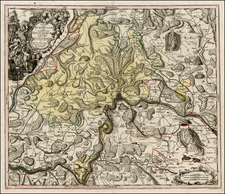
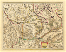
Rare separately published map of the Canton of Bern, published in Bern in 1694.
The map covers the Bern and the neighboring Cantons of Fribourg, Vaud and Neuchatel and includes a large inset map of the City of Berne. The map captures the rugged Alpine terrain of the region, with many lakes, mountains, and rivers shown.
This is one of two rare early maps of the canton of Bern based on the maps of Thomas Schöpf of 1578, the other map being by Joseph Plepp (Noua et compendiosa inclÿtæ vrbis et agri Bernensis descriptio geographica, 1638).
The note at the left translates as follows:
Here you have the territories and the Bernese region, along with the neighboring places of Nodam, in an accurate description, indeed in various editions, but most carefully in all. One indeed is very large and is entirely and very contracted, another is brief and drawn from this through a network with all its errors delineated. In the remaining parts, many particular places are omitted, all of them, or obscure places are sometimes put aside, and the sites of places and distances are scarcely consistent, etc., so much so that of all these numerous errors arise. And there is usually a use. But indeed, due to the narrowness of this table, some names have been omitted to avoid confusion, that brief one in this much larger one is now delineated (with Dominatus Bernensis Ursi effigie adiectus) I will supply in the meantime.
This is the first state of the map, which was re-issued in 1734.
Rarity
OCLC locates 3 copies, all in Switzerland.