


|
||

|

|
|

|
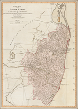
Mapping The Mount Everest Region and the Mountains of Nepal
Highly detailed map of the Dudh Kosi region, an area in Eastern Nepal often used in navigation to Everest Base Camp, the starting point for many summit runs. Produced in 1974 by avid climber and cartographer Erwin Schneider, this map sought to provide accurate data on the Everest region for future expeditions. Summited for the first time only twenty years prior, Mt. Everest became an increasingly popular attraction for scientists, national climbing groups, and even ordinary enthusiasts. As such, demand for accurate maps of the region was on the rise as more teams came into the region every year.
The map includes a wealth of infrastructure data such as houses/shelters, accessible roads, and airfields; vital for both local commuting and international travelers. The list of "Tibetan and Sherpa Words" alongside "Nepali Words" is mostly focused on geographical concerns that would affect a climb or survey of the region. These features imply that this map was used as a practical tool for navigation and understanding of the region's topography. The fact that it is published in both German and English also indicates the increased desire of many Western tourists to visit or summit Everest. Altogether, this map showcases an important period in the history of Mt. Everest, a period that involved an increased interest in exploration and enjoyment of the region.
Erwin Schneider & Mapping The Everest & Nepal
Erwin Schneider was both a prominent mountain climber and a cartographer. Starting in the 1930s, Schneider embarked on various expeditions in the Himalayas. His journeys covered a range of peaks, some of which were relatively unexplored at the time.
Schneider's contributions to cartography are notable, especially regarding the Himalayan region. He was instrumental in creating the first detailed topographical maps of the Everest region, employing the method of photogrammetry. This technique uses photographs for measurement and mapping, particularly useful for the rugged terrains of Nepal.
Work on this series of maps dates back to 1959 with the inception of the Research Scheme Nepal Himalaya. The foundation of this scheme was under the leadership of Walter Hellmich, a distinguished zoologist. The first project was the comprehensive mapping of the Mt. Everest region executed by Erwin Schneider. By 1977, Schneider's efforts culminated in the publishing of eight pivotal maps. These included detailed representations of East Nepal and the culturally significant Kathmandu Valley.
In 1961, the Fritz Thyssen Foundation assumed the responsibility of sponsoring various field research projects and bolstered the publication of the Khumbu Himal series of maps. Between 1960 and 1966, nine dedicated research groups, comprising 38 participants, embarked on diversified projects predominantly centered in East Nepal, notably the Dudh Kosi area. The resultant findings from these explorations found their way into prominent publications such as the Khumbu Himal and Hochgebirgsforschung series.
In 1965, the Research Council of the Research Scheme Nepal Himalaya became the Association of Comparative High Alpine Research. Nepal, with its diverse topography and rich culture, continued to be the focal point of this Association's endeavors. An interesting shift in the composition of the Association members was noted over the years. While initially dominated by natural scientists, representation from the humanities started to gain prominence, especially with the inclusion of ethnologists and human geographers.
Integral to their research processes was the establishment of a base in Kathmandu named the "Nepal Research Center", also colloquially known as the "Thyssen House". This center, aided by a bilateral treaty between Nepal and the Federal Republic of Germany, facilitated smoother customs procedures and granted crucial research permits. This center underwent a transition in 1974, with the German Oriental Society taking over the project and subsequently inaugurating a new Research Center in Ganabahal.
![Expedition Citroen Centre-Asie 3eme Mission G.-M. Haardt - L. Audouin-Dubreuil [with 2 official pamphlets for the route, etc.]](https://storage.googleapis.com/raremaps/img/small/63033.jpg)
![[ Southern Hainan Coast ] A Chart of the South Coast of Haynan from Tinhosa to Guichou](https://storage.googleapis.com/raremaps/img/small/94735.jpg)
![[Nepal to Myanmar and Eastern Thailand] Eastern Bengal, Assam, Burmah, and Parts of China and Siam 1870. With Additions and Corrections to 1875.](https://storage.googleapis.com/raremaps/img/small/76653.jpg)