


|
||

|

|
|

|
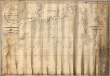
Updated With Many New Railroad Stations and Completed Railroad Lines
Rare separately published map of the region from Nepal and Eastern India to Myanmar, Thailand and the Yunnan region of southwestern China, published in Calcutta by the Surveyor General of India.
The present example of the map would seem to be the third state, with significant improvements and additions relating the the railroad lines and railroad stations throughout the region, but primarily in the areas of Calcutta and to the north (Kolkata) and Rangoon (Yangon).
This is a remarkably detailed map of the region, meticulously compiled and periodically updated between 1870 and 1885. The map shows roads, railways, division, district and international boundaries, with relief shown by shading. The inset map shows a continuation of Tenasserim provinces and Malay peninsula.
While not specifically noted in the text, the map also shows a number of interior steamship and "Large Boat" routes into the interior regions.
One of the major features of the map is its meticulous accounting on the routes of 9 explorers in the region, including:
- Dr. Richardson 1830-1857
- Captain McLeod 1837
- Captain Watson and Mr. Fedden 1854-44
- Mr. O'Riley 1855-56
- The French Expedition 1866-68
- Captain Watson, Lt. Sconce and Mr. O'Riley 1863-64
- Captain Williams and Luard 1867
- Mr. Cooper's Route through Upper Assam and Western China 1869
The map also provides a list of (rare to unobtainable) sources used to create the map, including:
- Map of Eastern Frontier of Bengal, 1865
- Map of Bengal, Behar & Orissa, 1868
- Map of the Pegu Division British Burmah by Captain Fitzroy and Captain Edgcome 1863
- Colonel Yule's Map of Burmah, 1857
- Stanford's Map of China 1862
- Central Part of British Burmah with the Shan Province &c. by Trelawny Saunders 1870
- Captain T.G. Montgomerie's Map of the Pundits Routes in Thibet, 1867.
First published in 1870, the present example is drawn from a Survey printed in June 1875, with the addition of Railway Lines as of November 1885.
Rarity
We note only a single example of this edition of the map in the Bibliotheque National de France (1885 edition with Railroad information).
![[Dutch Forts -- Jakarta, Amboine, Ternate, Solor, Banda] Vue et Description de Quelques-Uns des Principaux Forts des Hollandois dans les Indes](https://storage.googleapis.com/raremaps/img/small/43122.jpg)