|
||

|

|
|

|
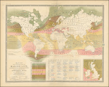
The Geographical Distribution of Health & Disease, by Alexander Keith Johnston, and engraved by W. & A.K. Johnston in Edinburgh in the 1850s, provides a systematic representation of global health patterns in relation to certain natural phenomena. The map notably tracks the spread of cholera from East to West using a red line, noting dates of occurrence. Additionally, blue lines marking the positions of British naval stations abroad and zones of diet delineated by the Tropics of Cancer and Capricorn are included. An inset emphasizes the fever districts of the United States and the West Indies.
The 19th century saw an increased effort to comprehend the distribution and causality of diseases worldwide. With growing globalization, colonial expansion, and international trade routes, the spread of diseases like cholera became a significant concern. Johnston's map catered to the needs of the period, helping professionals track disease movements and devise interventions. The inclusion of the foreign stations of the British Navy offers a glimpse into naval routes and their potential relationship with health trends.
Complementing the primary map are charts detailing health statistics, such as the prevalence of rheumatism and consumption among global populations. Johnston's comparative evaluation of life expectancy in different countries and cities highlights health disparities of the era. The data on mortality rates of European residents in foreign territories underscores health concerns in overseas endeavors, presenting statistics from locales like Cape of Good Hope to St. Lucia.
Overall, Johnston's work, supported by his affiliation with the Epidemiological Society of London, presents a studied overview of global health trends in the 19th century.
![[ World on Mercator's Projection ] Mappe-Monde suivant la projection de Mercator -- 1832](https://storage.googleapis.com/raremaps/img/small/99031.jpg)